Elba
 From Conservapedia
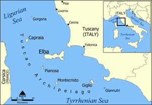
 Elba is an Italian island in the Mediterranean Sea between the Italian mainland and the French island of Corsica. It is separated from the Tuscan coast of Italy by the 6.2 mile wide Prombino Channel. Like Tuscany, it is part of the Province of Livorne.
The island has an area of 86 square miles, and a population of a little over 32,000. It is mainly mountainous (highest point, Monte Capanne, 3342 ft.) with some level areas at the head bays and inlets on the generally rocky coast where vines, olives and mulberries are cultivated. The main industries are tourism and the mining of iron ore, for which the island has been famed since ancient times.
The capital, main port, and industrial and commercial centre is Portoferraio (population, approximately 12000) on the north coast facing the Ligurian Sea. By the standards of the region it is a modern town, having been built in the 16th century on and near the ruins of the ancient Roman town of Fabricia.
Elba was the site of Napoleon Bonaparte's "kingdom in exile" from May, 1814 till February, 1815, when he escaped to recommence his career for the "100 days" before Waterloo.
An island in the American state of Georgia within the Savannah River has been named after the Italian island. The American island is known as a site of a liquified natural gas terminal.
References[edit]
- Chamber's Encyclopaedia, 1959.
- http://www.visitelba.co.uk/resort/portoferraio-elba-the-gateway-to-the-island/
Categories: [Italian Islands]
↧ Download as ZWI file | Last modified: 03/07/2023 22:09:25 | 37 views
☰ Source: https://www.conservapedia.com/Elba | License: CC BY-SA 3.0
 ZWI signed:
 KSF
KSF