Mount Wilbur (Alaska)
 From Handwiki
 | Mount Wilbur | |
|---|---|
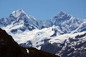 Mts Orville and Wilbur | |
| Highest point | |
| Elevation | 10,821 ft (3,298 m) [1] |
| Prominence | 3,963 ft (1,208 m) [1] |
| Coordinates | [ ⚑ ] 58°44′24″N 137°19′07″W / 58.74°N 137.31861°W |
| Geography | |
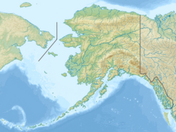 Mount Wilbur Glacier Bay National Park and Preserve, Alaska, U.S. | |
| Parent range | Fairweather Range, Saint Elias Mountains |
| Topo map | USGS Mount Fairweather C-4 Quadrangle |
| Climbing | |
| First ascent | 1975 by D. Jones, C. Gerhardt, C. McKibben |
| Easiest route | snow/ice climb |
Mount Wilbur is a high peak of the Fairweather Range, the southernmost part of the Saint Elias Mountains. It lies approximately 14 miles (22 km) southeast of Mount Fairweather and 8 miles (13 km) northwest of Mount Crillon. It is included in Glacier Bay National Park. The peak is the higher of a pair of peaks, Mounts Wilbur and Orville, named after the Wright Brothers.
Though not a particularly high peak in absolute terms, Mount Wilbur does stand quite high above local terrain, due to its proximity to the ocean: the summit is only 7.5 miles from tidewater at the head of Lituya Bay to the southwest.
References
- ↑ 1.0 1.1 "Mount Wilbur". http://www.bivouac.com/MtnPg.asp?MtnId=11699. Retrieved 14 Dec 2013.
External links
- Mount Wilbur on Topozone
- Mount Wilbur on bivouac.com
 |  |
Categories: [Mountains of Alaska]
↧ Download as ZWI file | Last modified: 09/04/2024 09:48:54 | 3 views
☰ Source: https://handwiki.org/wiki/Earth:Mount_Wilbur_(Alaska) | License: CC BY-SA 3.0
✘
ZWI is not signed. [what is this?]
ZWI viewer
by the  KSF
KSF