Nunavut
 From Conservapedia
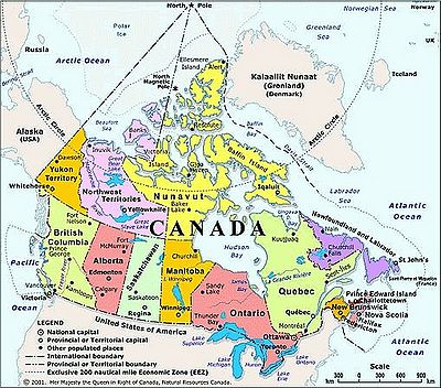
 Nunavut has the lowest population of all Canadian Provinces and Territories and the capital is Iqaluit (formerly "Frobisher Bay") on Baffin Island, which in the east of the Territory. The population of the entire territory is only 30,000 (approximately) of whom 85% are native people. The territory covers nearly 1.9 million km2 of land and water, including all of the islands in Hudson Bay, James Bay and a section of mainland, north of Manitoba and east of the Northwest Territories. 20% of Canada's land is in Nunavut.[1]
Much of the land is on the Canadian Shield, a bedrock formation with only thin soil lying on top, and in many places no soil at all.
Nunavut means 'our land' in Inuktitut. The territory was intended to be an area of limited self-rule by the Inuit of Canada.
Further reading[edit]
- Canadian Encyclopedia (2008) reliable detailed encyclopedia, on-line free
External links[edit]
References[edit]
Categories: [Nunavut] [Canada] [Canadian Provinces] [Canadian History] [Canadian Geography] [Survivalism] [Arctic Circle]
↧ Download as ZWI file | Last modified: 03/17/2023 01:03:47 | 85 views
☰ Source: https://www.conservapedia.com/Nunavut | License: CC BY-SA 3.0
 ZWI signed:
 KSF
KSF