Indian Subcontinent
 From Handwiki
 Error: no inner hatnotes detected (help).
| Area | 4,440,000 km2 (1,710,000 sq mi) |
|---|---|
| Population | c. 1.8 billion |
| Demonym | South Asian Desi (colloquial) |
| Countries | 7
|
| Dependencies | External (1)
Disputed (1)
|
| Languages | Official languages:
|
| Time zones | List:
|
| Largest cities | 10 largest cities on the Indian subcontinent
|
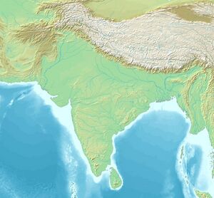
The Indian subcontinent[note 7] is a physiographical region in Southern Asia, mostly situated on the Indian Plate, projecting southwards into the Indian Ocean from the Himalayas. Geopolitically, it spans major landmasses from the countries of Bangladesh, Bhutan, India ,[note 1] Maldives,[note 2] Nepal,[note 3] Pakistan ,[note 4] and Sri Lanka.[note 2][1][2][3][4] Although the terms "Indian subcontinent" and "South Asia" are often used interchangeably to denote the region,[5] the geopolitical term of South Asia frequently includes Afghanistan, which is not considered part of the subcontinent.[6]
Geologically, the subcontinent originates from Insular India, an isolated landmass that rifted from the supercontinent of Gondwana during the Cretaceous and merged with the landmass of Eurasia nearly 55 million years ago, forming the Himalayas.[7] Historically, as well as to the present day, it is and has been the most populated region in the world, holding roughly 20–25 percent of the global population at all times in history. Geographically, it is the peninsular region in Southern Asia located below the Third Pole, delineated by the Himalayas in the north, the Hindu Kush in the west, and the Indo-Burman Ranges in the east.[8] The neighboring geographical regions around the subcontinent include the Tibetan Plateau to the north, the Indochinese Peninsula to the east, and the Iranian Plateau to the west and the Indian Ocean to the south.
Name
In many historical sources, the region surrounding and southeast of the Indus River was referred to simply as "India".[9] Historians continue to use this term to refer to the whole of the Indian subcontinent in discussions of history up until the era of the British Raj.[9] During this period, "India" came to refer to a distinct political entity that later became a nation-state.[9]
According to the Oxford English Dictionary, the term subcontinent signifies a "subdivision of a continent which has a distinct geographical, political, or cultural identity" and also a "large land mass somewhat smaller than a continent".[10][11] Its use to signify the Indian subcontinent is evidenced from the early twentieth century when most of the territory was either part of the British Empire or allied with them.[12][13] It was a convenient term to refer to the region comprising both British India and the princely states.[14][15]
The term has been particularly common in the British Empire and its successors,[16] while the term South Asia is the more common usage in Europe and North America.[17][18] According to historians Sugata Bose and Ayesha Jalal, the Indian subcontinent has come to be known as South Asia "in more recent and neutral parlance".[19] Indologist Ronald B. Inden argues that the usage of the term South Asia is becoming more widespread since it clearly distinguishes the region from East Asia.[20] While South Asia, a more accurate term that reflects the region's contemporary political demarcations, is replacing the Indian subcontinent, a term closely linked to the region's colonial heritage, as a cover term, the latter is still widely used in typological studies.[21][22]
Since the partition of India, citizens of Pakistan (which became independent of British India in 1947) and Bangladesh (which became independent of Pakistan in 1971) often perceive the use of the Indian subcontinent as offensive and suspicious because of the dominant placement of India in the term. As such it is being increasingly less used in those countries.[note 8] Meanwhile, many Indian analysts prefer to use the term because of the socio-cultural commonalities of the region.[24] The region has also been called the "Asian subcontinent",[25][26] the "South Asian subcontinent",[27][28][29] as well as "India" or "Greater India" in the classical and pre-modern sense.[5][6][30][31]
Geology
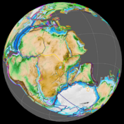
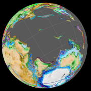
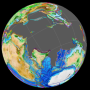
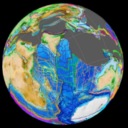
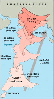
The Indian subcontinent was formerly part of Gondwana, a supercontinent formed during the late Neoproterozoic and early Paleozoic.[7] Gondwana began to break up during the Mesozoic, with Insular India separating from Antarctica 130-120 million years ago[32] and Madagascar around 90 million years ago,[33] during the Cretaceous. Insular India subsequently drifted northeastwards, colliding with the Eurasian Plate nearly 55 million years ago, during the Eocene, forming the Indian subcontinent.[7] The zone where the Eurasian and Indian subcontinent plates meet remains geologically active, prone to major earthquakes.[34][35]
Physiographically, it is a peninsular region in South Asia delineated by the Himalayas in the north, the Hindu Kush in the west, and the Arakanese in the east.[8][36] It extends southward into the Indian Ocean with the Arabian Sea to the southwest and the Bay of Bengal to the southeast.[1][37] Most of this region rests on the Indian Plate and is isolated from the rest of Asia by large mountain barriers.[38] Laccadive Islands, Maldives and the Chagos Archipelago are three series of coral atolls, cays and Faroes on the Indian plate along with the Chagos–Laccadive Ridge, a submarine ridge that was generated by the northern drift of the Indian Plate over the Réunion hotspot during the Cretaceous and early Cenozoic times.[39][40][41] The Maldives archipelago rises from a basement of volcanic basalt outpourings from a depth of about 2000 m forming the central part of the ridge between Laccadives and the Great Chagos Bank.[41]
Geography
According to anthropologist Patrap C. Dutta, "the Indian subcontinent occupies the major landmass of South Asia."[42] According to historian B. N. Mukherjee, "The subcontinent is an indivisible geographical entity."[43] According to geographer Dudley Stamp, "there is perhaps no mainland part of the world better marked off by nature as a region or a 'realm' by itself than the Indian subcontinent."[44]
This natural physical landmass in Southern Asia is the dry-land portion of the Indian Plate, which has been relatively isolated from the rest of Eurasia.[45] The Himalayas (from Brahmaputra River in the east to Indus River in the west), Karakoram (from Indus River in the east to Yarkand River in the west) and the Hindu Kush mountains (from Yarkand River westwards) form its northern boundary.[43][46] In the west it is bounded by parts of the mountain ranges of Hindu Kush, Spīn Ghar (Safed Koh), Sulaiman Mountains, Kirthar Mountains, Brahui range, and Pab range among others,[43] with the Western Fold Belt along the border (between the Sulaiman Range and the Chaman Fault) is the western boundary of the Indian Plate,[47] where, along the Eastern Hindu Kush, lies the Afghanistan–Pakistan border.[48] In the east, it is bounded by Patkai, Naga, Lushai and Chin hills.[43] The Indian Ocean, Bay of Bengal and Arabian Sea form the boundary of the Indian subcontinent in the south, south-east and south-west.[43]
Given the difficulty of passage through the Himalayas, the sociocultural, religious and political interaction of the Indian subcontinent has largely been through the valleys of Afghanistan in its northwest,[citation needed] the valleys of Manipur in its east, and by maritime routes.[45] More difficult but historically important interaction has also occurred through passages pioneered by the Tibetans. These routes and interactions have led to the spread of Buddhism out of the subcontinent into other parts of Asia. The Islamic expansion arrived into the subcontinent in two ways: through Afghanistan on land, and to the Indian coast through the maritime routes on the Arabian Sea.[45]
Geopolitics
In terms of modern geopolitical boundaries, the subcontinent constitutes Bangladesh, Bhutan, India , Nepal, and Pakistan , besides, by convention, the island country of Sri Lanka and other nearby island nations of the Indian Ocean, such as Maldives and the British Indian Ocean Territory.[citation needed][original research?][2][3][49][50][51] Unlike "South Asia" sometimes the expression "Indian subcontinent" may exclude the islands of Maldives and Sri Lanka.[5] According to Chris Brewster and Wolfgang Mayrhofer, India, Pakistan, Bangladesh, Sri Lanka, Nepal and Bhutan constitute the Indian subcontinent. Brewster and Mayrhofer also maintain that with Afghanistan and Maldives included the region is referred to as South Asia.[52] The periphery of the subcontinent, including Pakistan, Bangladesh and the island chains of the Maldives, features large Muslim populations, while the heartland, including most of India, Nepal and Sri Lanka, are overwhelmingly Hindu or Buddhist.[53] Since most of these countries are located on the Indian Plate, a continuous landmass, the borders between countries are often either a river or a no man's land.[54]
The precise definition of an "Indian subcontinent" in a geopolitical context is somewhat contested as there is no globally accepted definition on which countries are a part of South Asia or the Indian subcontinent.[55][56][57][4] Whether called the Indian subcontinent or South Asia, the definition of the geographical extent of this region varies.[30][31] Afghanistan, despite often considered as a part of South Asia, is usually not included in the Indian subcontinent.[55][58][59][60][61] Maldives, an island country consisting of a small archipelago southwest of the peninsula, while largely considered a part of the Indian subcontinent,[3] sometimes is mentioned by sources, including the International Monetary Fund, as a group of islands away from the Indian subcontinent in a south-western direction.[62][63]
See also
- Arabian Peninsula
- Greater India
- Hindustan
- Iranian Plateau
- South Asia
- South Asian Association for Regional Cooperation (SAARC)
Notes
- ↑ 1.0 1.1 Excluding:
- Andaman and Nicobar Islands, which is a part of the Malay Archipelago.
- Ladakh, Spiti, and other areas which lie to the north of the Greater Himalayan Mountain Range.
- Significant portions of northeast India which lie on the Indo-Burman Ranges (spanning Manipur, Nagaland and Mizoram) as well as the Tibetan Plateau (northern Arunachal Pradesh and Sikkim)
- ↑ 2.0 2.1 2.2 2.3 As island countries, Maldives and Sri Lanka are sometimes not considered part of the subcontinent, as they lack geographic contiguity with the mainland. They are considered parts of the region in cultural geography or geology instead.
- ↑ 3.0 3.1 Excluding Upper Mustang and other areas which lie to the north of the Greater Himalayan Mountain Range.
- ↑ 4.0 4.1 Excluding:
- Significant landmasses from East Balochistan and Khyber Pakhtunkhwa (like Federally Administered Tribal Areas) which are situated on the Iranian Plateau.
- Parts of Northern Areas (like Baltistan) which lie to the north of the Greater Himalayan Mountain Range.
- ↑ Administered by the United Kingdom , claimed by Mauritius as the Chagos Archipelago.
- ↑ Template:Kashmir-note
- ↑ It is sometimes simply just referred as the subcontinent in South Asian contexts.
- ↑ For example, a history book intended for Pakistani B.A. students by K. Ali uses the term "Indo-Pakistan" instead.[23]
References
- ↑ 1.0 1.1 "Indian subcontinent". New Oxford Dictionary of English (ISBN:0-19-860441-6) New York: Oxford University Press, 2001; p. 929: "the part of Asia south of the Himalayas which forms a peninsula extending into the Indian Ocean, between the Arabian Sea and the Bay of Bengal. Historically forming the whole territory of Greater India, the region is now divided into three countries named Bangladesh, India and Pakistan."
- ↑ 2.0 2.1 Dhavendra Kumar (2012). Genomics and Health in the Developing World. Oxford University Press. p. 889. ISBN 978-0-19-537475-9. https://books.google.com/books?id=BLLmbgt8wNgC&pg=PA889.
- ↑ 3.0 3.1 3.2 Mariam Pirbhai (2009). Mythologies of Migration, Vocabularies of Indenture: Novels of the South Asian Diaspora in Africa, the Caribbean, and Asia-Pacific. University of Toronto Press. p. 14. ISBN 978-0-8020-9964-8. https://books.google.com/books?id=EsCZZ3K6-uYC&pg=PA14.
- ↑ 4.0 4.1 Michael Mann (2014). South Asia's Modern History: Thematic Perspectives. Taylor & Francis. pp. 13–15. ISBN 978-1-317-62445-5. https://books.google.com/books?id=Uh0cBQAAQBAJ&pg=PT13.
- ↑ 5.0 5.1 5.2 McLeod, John (2002). The history of India. Greenwood Press. p. 1. ISBN 0-313-31459-4. Note: McLeod does not include Afghanistan in the Indian subcontinent or South Asia.
- ↑ 6.0 6.1 Jim Norwine & Alfonso González, The Third World: states of mind and being, pages 209, Taylor & Francis, 1988, ISBN:0-04-910121-8 Quote: ""The term "South Asia" also signifies the Indian Subcontinent""
Raj S. Bhopal, Ethnicity, race, and health in multicultural societies, pages 33, Oxford University Press, 2007, ISBN:0-19-856817-7; Quote: "The term South Asian refers to populations originating from the Indian subcontinent, effectively India, Pakistan, Bangladesh and Sri Lanka;
Lucian W. Pye & Mary W. Pye, Asian Power and Politics, pages 133, Harvard University Press, 1985, ISBN:0-674-04979-9 Quote: "The complex culture of the Indian subcontinent, or South Asia, presents a tradition comparable to Confucianism."
Mark Juergensmeyer, The Oxford handbook of global religions, pages 465, Oxford University Press US, 2006, ISBN:0-19-513798-1
Sugata Bose & Ayesha Jalal, Modern South Asia, page 3, Routledge, 2004, ISBN:0-415-30787-2 - ↑ 7.0 7.1 7.2 Robert Wynn Jones (2011). Applications of Palaeontology: Techniques and Case Studies. Cambridge University Press. pp. 267–271. ISBN 978-1-139-49920-0. https://books.google.com/books?id=mrPiq_8pkAwC&pg=PA267.
- ↑ 8.0 8.1 Baker, Kathleen M.; Chapman, Graham P. (11 March 2002), The Changing Geography of Asia, Routledge, pp. 10–, ISBN 978-1-134-93384-6, https://books.google.com/books?id=G-KIAgAAQBAJ&pg=PA10, "This greater India is well defined in terms of topography; it is the Indian sub-continent, hemmed in by the Himalayas on the north, the Hindu Khush in the west and the Arakanese in the east."
- ↑ 9.0 9.1 9.2 "Indian subcontinent Map, Countries, Population, & History". 2022-09-20. https://www.britannica.com/place/Indian-subcontinent.
- ↑ Webster's Third New International Dictionary, Unabridged, Merriam-Webster, 2002. Retrieved 6 December 2016; Quote: "a large landmass smaller than a continent; especially: a major subdivision of a continent ! e Indian subcontinent | "
- ↑ Subcontinent, Oxford English Dictionaries (2012). Retrieved 6 December 2016; Quote: "A large distinguishable part of a continent..."
- ↑ Milton Walter Meyer, South Asia: A Short History of the Subcontinent, pages 1, Adams Littlefield, 1976, ISBN:0-8226-0034-X
- ↑ "Indian subcontinent" is used by Henry D. Baker, British India With Notes On Ceylon Afghanistan And Tibet (1915), p. 401.
- ↑ subcontinent (3rd ed.), Oxford University Press, September 2005, http://www.oed.com/view/Entry/192528 (Subscription or UK public library membership required.)
- ↑ Indian subcontinent (3rd ed.), Oxford University Press, September 2005, http://www.oed.com/view/Entry/94389 (Subscription or UK public library membership required.)
- ↑ Milton Walter Meyer, South Asia: A Short History of the Subcontinent, pages 1, Adams Littlefield, 1976, ISBN:0-8226-0034-X
Jim Norwine & Alfonso González, The Third World: states of mind and being, pages 209, Taylor & Francis, 1988, ISBN:0-04-910121-8
Boniface, Brian G.; Christopher P. Cooper (2005). Worldwide destinations: the geography of travel and tourism. Butterworth-Heinemann. ISBN 978-0-7506-5997-0. https://books.google.com/books?id=c46i9jr9mhgC&pg=PA344.
Judith Schott & Alix Henley, Culture, Religion, and Childbearing in a Multiracial Society, pages 274, Elsevier Health Sciences, 1996, ISBN:0-7506-2050-1
Raj S. Bhopal, Ethnicity, race, and health in multicultural societies, pages 33, Oxford University Press, 2007, ISBN:0-19-856817-7
Lucian W. Pye & Mary W. Pye, Asian Power and Politics, pages 133, Harvard University Press, 1985, ISBN:0-674-04979-9
Mark Juergensmeyer, The Oxford handbook of global religions, pages 465, Oxford University Press US, 2006, ISBN:0-19-513798-1 - ↑ Judith Schott & Alix Henley, Culture, Religion, and Childbearing in a Multiracial Society, pages 274, Elsevier Health Sciences, 1996, ISBN:0750620501
- ↑ Raj S. Bhopal, Ethnicity, race, and health in multicultural societies, pages 33, Oxford University Press, 2007, ISBN:0198568177
- ↑ Bose, Sugata; Jalal, Ayeha (2004). Modern South Asia. Routledge. p. 3. ISBN 0415307872. https://archive.org/details/modernsouthasiah00bose/page/3/mode/1up.
- ↑ Ronald B. Inden, Imagining India, page 51, C. Hurst & Co. Publishers, 2000, ISBN:1850655200
- ↑ McArthur, Tom (2003). The Oxford Guide to World English. Oxford University Press. p. 309. ISBN 9780198607717.
- ↑ Lange, Claudia (2012). "Standards of English in South Asia". in Raymond Hickey. Standards of English: Codified Varieties around the World. Cambridge University Press. p. 256. ISBN 9781139851213. https://books.google.com/books?id=gZV7AAAAQBAJ&pg=PA256.
- ↑ Ali, K. (1980). A New History of Indo-Pakistan up to 1526 (4th ed.). Lahore: Aziz Publishers.
- ↑ B.H. Farmer, An Introduction to South Asia, page 1, Methuen and Co. Ltd., 1983, ISBN:9780416726008, "The 'Indian sub continent' is a term that certainly recognises the dominant position of India in both area and population. Since the partition of Indian Empire, use of this term becomes offensive to the Pakistanis and the Bangladeshis."
Jona Razzaque, Public Interest Environmental Litigation in India, Pakistan, and Bangladesh, page 3, Kluwer Law International, 2004, ISBN:9789041122148 "Yet, because citizens of Pakistan (which was carved out of India in 1947 and has had recurring conflicts with India since then) and of Bangladesh (which became separated from Pakistan by civil war in 1971) might find offensive the dominant placement of India in the term "Indian subcontinent", many scholars today prefer the more recently adopted designation 'South Asia.'"
Sushil Mittal and Gene Thursby, Religions of South Asia: An Introduction, page 3, Routledge, 2006, ISBN:9781134593224
S K Shah, India and Its Neighbours: Renewed Threats and New Directions, page 26, Vij Books India Pvt Ltd, 2017, ISBN:9789386367501 "Indian analysts, who talk of the Indian sub-continent, wish to keep in mind, in their analyses, the common historical, political, religious and cultural heritage of these three countries. The term sub-continent is used less and less in Pakistan and Bangladesh. The political leadership and the policy-makers in these two countries do not wish to be reminded of this common heritage. Any highlighting of this common heritage by Indian analysts is viewed by them with suspicion—— as indicating a hidden desire to reverse history and undo the 1947 partition." - ↑ Lizzie Crouch and Paula McGrath, "Humanity's global battle with mosquitoes", Health check, BBC World Service
- ↑ K. Alan Kronstadt, Terrorist Attacks in Mumbai, India, and Implications for U. S. Interests, page 7, Diane Publishing, 2011, ISBN:9781437929539
- ↑ Aijazuddin Ahmad, Geography of the South Asian subcontinent: A Critical Approach, page 17, Concept Publishing Company, 2009, ISBN:9788180695681
- ↑ Ayesha Jalal (2008). Partisans of Allah: Jihad in South Asia. Harvard University Press. p. xiii. ISBN 9780674028012. https://archive.org/details/partisansofallah00ayes.
- ↑ K. D. Kapur, Nuclear Non-proliferation Diplomacy: Nuclear Power Programmes in the Third World, page 365, Lancers Books, 1993, ISBN:9788170950363|Daya Nath Tripathi (ed), Discourse on Indo European Languages and Culture, page 193, Indian Council of Historical Research, 2005, ISBN:9788178271200
Muhammad Akram Khan, What Is Wrong with Islamic Economics?: Analysing the Present State and Future Agenda, page 183, Edward Elgar Publishing, 2013, ISBN:9781782544159 - ↑ 30.0 30.1 Sushil Mittal and Gene Thursby, Religions of South Asia: An Introduction, page 3, Routledge, 2006, ISBN:9781134593224
- ↑ 31.0 31.1 Kathleen M. Baker and Graham P. Chapman, The Changing Geography of Asia, page 10, Routledge, 2002, ISBN:9781134933846
- ↑ Gaina, Carmen; Müller, R. Dietmar; Brown, Belinda; Ishihara, Takemi; Ivanov, Sergey (July 2007). "Breakup and early seafloor spreading between India and Antarctica" (in en). Geophysical Journal International 170 (1): 151–169. doi:10.1111/j.1365-246X.2007.03450.x. Bibcode: 2007GeoJI.170..151G.
- ↑ Torsvik, T.H.; Tucker, R.D.; Ashwal, L.D.; Carter, L.M.; Jamtveit, B.; Vidyadharan, K.T.; Venkataramana, P. (October 2000). "Late Cretaceous India-Madagascar fit and timing of break-up related magmatism" (in en). Terra Nova 12 (5): 220–224. doi:10.1046/j.1365-3121.2000.00300.x. ISSN 0954-4879. Bibcode: 2000TeNov..12..220T. http://doi.wiley.com/10.1046/j.1365-3121.2000.00300.x.
- ↑ Bethany D. Rinard Hinga (2015). "Eurasian Plate". Ring of Fire: An Encyclopedia of the Pacific Rim's Earthquakes, Tsunamis, and Volcanoes. ABC-CLIO. pp. 89–90. ISBN 978-1-61069-297-7. https://books.google.com/books?id=VHq1BgAAQBAJ.
- ↑ Alexander E. Gates; David Ritchie (2006). Encyclopedia of Earthquakes and Volcanoes. Infobase. pp. 116–118. ISBN 978-0-8160-7270-5. https://books.google.com/books?id=b1sXfJCiCHQC.
- ↑ Dhavendra Kumar (2012). Genomics and Health in the Developing World. Oxford University Press. pp. 889–890. ISBN 978-0-19-537475-9. https://books.google.com/books?id=BLLmbgt8wNgC&pg=PA889.
- ↑ McLeod, John (2002). The history of India. Greenwood Press. p. 2. ISBN 0-313-31459-4.
- ↑ Pannell, Clifton W. (2009). "Asia". Encyclopædia Britannica. https://www.britannica.com/EBchecked/topic/38479/Asia. "The paleotectonic evolution of Asia terminated some 50 million years ago as a result of the collision of the Indian subcontinent with Eurasia. Asia's subsequent neotectonic development has largely disrupted the continents pre-existing fabric. The neotectonic units of Asia are Stable Asia, the Arabian and Indian cratons, the Alpide plate boundary zone (along which the Arabian and Indian platforms have collided with the Eurasian continental plate), and the island arcs and marginal basins.".
- ↑ E. Bredow, R. Gassmöller, J. Dannberg and B. Steinberger, Geodynamic Models of Plume-Ridge Interaction in the Indian Ocean and its Effect on the Crustal Thickness of the Réunion Hotspot Track (abstract), Astrophysics Data System (ADS), Harvard–Smithsonian Center for Astrophysics
- ↑ T.R. McClanahan, C.R.C. Sheppard and D.O. Obura, Coral Reefs of the Indian Ocean: Their Ecology and Conservation, page 327, Oxford University Press, 2000, ISBN:9780195352177
- ↑ 41.0 41.1 Rudie H. Kuiter and Timothy Godfrey, Fishes of the Maldives – Indian Ocean, page 1, Atoll Editions, 2014, ISBN:9781876410971
- ↑ Dutta, Patrap C. (1984). "Biological Anthropology of Bronze Age Harappans: New Perspectives". in Lukacs, John R.. The people of South Asia: the biological anthropology of India, Pakistan, and Nepal. Plenum Press. p. 59. ISBN 9780306414077.
- ↑ 43.0 43.1 43.2 43.3 43.4 Bratindra Nath Mukherjee, Nationhood and Statehood in India: A historical survey, page 4, Regency Publications, 2001, ISBN:9788187498261
- ↑ L. Dudley Stamp (1957). India, Pakistan, Ceylon and Burma. London: Methuen. p. 185. OCLC 213547929.
- ↑ 45.0 45.1 45.2 Asher, Catherine B.; Talbot, Cynthia (2006), India Before Europe, Cambridge University Press, pp. 5–8, 12–14, 51, 78–80, ISBN 978-0-521-80904-7, https://books.google.com/books?id=ZvaGuaJIJgoC
- ↑ Samiul Hasan, The Muslim World in the 21st Century: Space, Power, and Human Development, page 84, Springer Science & Business Media, 2012, ISBN:9789400726321
- ↑ S. Mukherjee, R. Carosi, P.A. van der Beek, B.K. Mukherjee and D.M. Robinson (ed.), Tectonics of the Himalaya, Geological Society of London, 2015, ISBN:9781862397033
- ↑ Shroder, John F. (2011). "Hindu Kush". Encyclopedia of Snow, Ice and Glaciers. Springer. p. 525. ISBN 978-90-481-2641-5.
- ↑ Dhavendra Kumar (2012). Genomics and Health in the Developing World. Oxford University Press. p. 889. ISBN 978-0-19-537475-9. https://books.google.com/books?id=BLLmbgt8wNgC&pg=PA889. Retrieved 9 December 2016. "India, Pakistan, Bangladesh, Sri Lanka, Nepal, Bhutan and other small islands of the Indian Ocean"
- ↑ Stephen Adolphe Wurm, Peter Mühlhäusler & Darrell T. Tryon, Atlas of languages of intercultural communication in the Pacific, Asia, and the Americas, pages 787, International Council for Philosophy and Humanistic Studies, Published by Walter de Gruyter, 1996, ISBN:3-11-013417-9
Haggett, Peter (2001). Encyclopedia of World Geography (Vol. 1). Marshall Cavendish. p. 2710. ISBN 0-7614-7289-4. - ↑ Vanhanen, Tatu (1997). Prospects of Democracy: A Study of 172 Countries. Routledge. p. 141. ISBN 978-0-415-14405-6. https://books.google.com/books?id=F9rta0WSZdUC&pg=PG141. ""The seven countries of South Asia constitute geographically a compact region around the Indian Subcontinent ... Nepal and Bhutan ... the Maldives""
- ↑ Chris Brewster and Wolfgang Mayrhofer, Handbook of Research on Comparative Human Resource Management, page 576, Edward Elgar Publishing, 2012, ISBN:9780857938718
- ↑ Salma K. Jayyusi, Renata Holod, Attilio Petruccioli and Andre Raymond, The City in the Islamic World, page 198, BRILL, 2008, ISBN:9789004162402
- ↑ Chandra K. Sharma, Geology of Nepal Himalaya and Adjacent Countries, page 14, Sangeeta Sharma Books, 1990, ASIN B0006EWSCI
- ↑ 55.0 55.1 Ewan W. Anderson; Liam D. Anderson (4 December 2013). An Atlas of Middle Eastern Affairs. Routledge. p. 5. ISBN 978-1-136-64862-5. https://books.google.com/books?id=n-VJAgAAQBAJ&pg=PA5., Quote: "To the east, Iran, as a Gulf state, offers a generally accepted limit to the Middle East. However, Afghanistan, also a Muslim state, is then left in isolation. It is not accepted as a part of Central Asia and it is clearly not part of the Indian subcontinent".
- ↑ Jona Razzaque (2004). Public Interest Environmental Litigation in India, Pakistan, and Bangladesh. Kluwer Law International. pp. 3 with footnotes 1 and 2. ISBN 978-90-411-2214-8. https://books.google.com/books?id=7E7al37aYBEC&pg=PA3.
- ↑ Akhilesh Pillalamarri, South Asia or India: An Old Debate Resurfaces in California, The Diplomat, 24 May 2016;
Ahmed, Mukhtar (2014), Ancient Pakistan – An Archaeological History: Volume II: A Prelude to Civilization, Foursome, p. 14, ISBN 978-1-4959-4130-6, https://books.google.com/books?id=HbvTBAAAQBAJ&pg=PA14 - ↑ Ira M. Lapidus (2014). A History of Islamic Societies. Cambridge University Press. pp. 269, 698–699. ISBN 978-0-521-51430-9. https://books.google.com/books?id=kFJNBAAAQBAJ&pg=PA698.
- ↑ Robert Wuthnow (2013). The Encyclopedia of Politics and Religion. Routledge. pp. 11–. ISBN 978-1-136-28493-9. https://books.google.com/books?id=MOVJAgAAQBAJ&pg=PA11.
- ↑ Kumar, Dhavendra (20 October 2004). Genetic Disorders of the Indian Subcontinent - Google Books. ISBN 9781402012150. https://books.google.com/books?id=bpl0LXKj13QC. Retrieved 20 July 2022.
- ↑ Prior, Katherine (1997). The History of Emigration from the Indian Subcontinent - Katherine Prior - Google Books. Franklin Watts. ISBN 9780531144183. https://books.google.com/books?id=B2ZXHAAACAAJ. Retrieved 20 July 2022.
- ↑ Ludwig Paul, Persian Origins, page 31, Otto Harrassowitz Verlag, 2003, ISBN:9783447047319, "Maldive Islands which are scattered about the sea south-west of the Indian subcontinent, extending over more than 1,000km in a north-south direction."
- ↑ Legal Department, International Monetary Fund, Maldives: Detailed Assessment Report on Anti-Money Laundering and Combating the Financing of Terrorism, page 15, International Monetary Fund, 2012, ISBN:9781463979676, "Maldives is the smallest Asian country in both population and land area. Its closest neighbors to the north are India's Laccadive Islands. To the northeast is the Indian subcontinent and Sri Lanka. To the south it borders the British Indian Occan Territory. About 2.600 kilometers (1,600 miles) further east, across the Indian Ocean, is Malaysia. To the west, the Horn of Africa is approximatcly 3,000 kilometers (1,300 miles) away."
Earth's primary regions | |||||||||||||||||
|---|---|---|---|---|---|---|---|---|---|---|---|---|---|---|---|---|---|
| |||||||||||||||||
 |  |
Categories: [Regions of Asia] [Continents]
↧ Download as ZWI file | Last modified: 08/05/2024 04:26:50 | 15 views
☰ Source: https://handwiki.org/wiki/Earth:Indian_subcontinent | License: CC BY-SA 3.0