Ravine
 From Handwiki
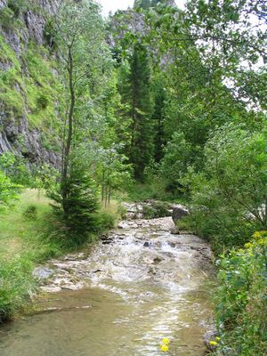
A ravine is a landform that is narrower than a canyon and is often the product of streambank erosion.[1] Ravines are typically classified as larger in scale than gullies, although smaller than valleys.[1] Ravines may also be called a cleuch, dell, ghout (Nevis), gill or ghyll, glen, gorge, kloof (South Africa ), and chine (Isle of Wight)
A ravine is generally a fluvial slope landform of relatively steep (cross-sectional) sides, on the order of twenty to seventy percent in gradient. Ravines may or may not have active streams flowing along the downslope channel which originally formed them; moreover, often they are characterized by intermittent streams, since their geographic scale may not be sufficiently large to support a perennial stream.[2]
Notable ravines
- Babi Yar, Ukraine
- Bam Bam Amphitheaters, Gabon
- Barranco de Badajoz, Spain
- Barranco del Infierno, Spain
- Gravina Ravine, Italy
- Moola Chotok, Pakistan
- Ravenna Park, United States
- Rauðfeldsgjá, Iceland
- Stuðlagil, Iceland
- Taishaku Valley, Japan
- Toronto ravine system, Canada
References
- ↑ 1.0 1.1 Definition of "ravine" at Merriam-Webster
- ↑ Christopher G. Morris; Academic Press (1992). Academic Press Dictionary of Science and Technology. Gulf Professional Publishing. pp. 1802–. ISBN 978-0-12-200400-1. https://books.google.com/books?id=nauWlPTBcjIC&pg=PA1802. Retrieved 1 October 2012.
External links
 |
Categories: [Erosion landforms] [Fluvial landforms] [Slope landforms]
↧ Download as ZWI file | Last modified: 08/08/2024 22:12:06 | 1 views
☰ Source: https://handwiki.org/wiki/Earth:Ravine | License: CC BY-SA 3.0


 KSF
KSF