Raised Shoreline
 From Handwiki
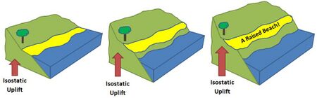
A raised shoreline is an ancient shoreline exposed above current water level.[1] These landforms are formed by a relative change in sea level due to global sea level rise, isostatic rebound, and/or tectonic uplift. These surfaces are usually exposed above modern sea level when a heavily glaciated area experiences a glacial retreat, causing water levels to rise. This area will then experience post-glacial rebound, effectively raising the shoreline surface.
Examples of raised shorelines can be found along the coasts of formerly glaciated areas in Ireland[2] and Scotland, as well as in North America. Raised shorelines are exposed at various locations around the Puget Sound of Washington State.[3]
See also
- Isostasy
- Landform
- Machair
- Marine terrace
- Parallel Roads of Glen Roy
- Raised beach
- Terrace (geology)
- Wave-cut platform
References
- ↑ http://www.encyclopedia.com/doc/1O112-raisedshorelines.html [|permanent dead link|dead link}}]
- ↑ http://www.askaboutireland.ie/.../changing-sea-levels/ [yes|permanent dead link|dead link}}]
- ↑ Kovanen, Dori J.; Slaymaker, Olav (December 2004). "Relict shorelines and ice flow patterns of the northern puget lowland from lidar data and digital terrain modelling" (in en). Geografiska Annaler: Series A, Physical Geography 86 (4): 385–400. doi:10.1111/j.0435-3676.2004.00239.x. ISSN 0435-3676. http://www3.interscience.wiley.com/journal/118781323/abstract.
Coastal geography | ||
|---|---|---|
| Landforms |
|   |
| Beaches |
| |
| Processes |
| |
| Management |
| |
| Related |
| |
| ||
 |  |
Categories: [Coastal geography] [Coastal and oceanic landforms]
↧ Download as ZWI file | Last modified: 07/14/2024 20:33:15 | 1 views
☰ Source: https://handwiki.org/wiki/Earth:Raised_shoreline | License: CC BY-SA 3.0