Plaine Des Sables
 From Handwiki
 Short description: Volcanic plateau of Réunion, France
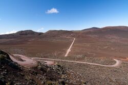
View of the Plaine des Sables from the Pas des Sables.
The Plaine des Sables (English: "Sands Plain") is a volcanic plateau in the mountains of Réunion, a France island in the Indian Ocean. Part of the Piton de la Fournaise massif, this volcanic desert is situated at the border of Saint-Joseph and Sainte-Rose, within Réunion National Park.[1][2]
References
- ↑ "Plaine des Sables". Discover Reunion. https://en.reunion.fr/organize/our-experiences/plaine-des-sables/. Retrieved 10 September 2021.
- ↑ "Plaine des sables". Cartedelareunion.fr. https://www.cartedelareunion.fr/listings/plaine-des-sables. Retrieved 10 September 2021.
[ ⚑ ] 21°13′48″S 55°39′36″E / 21.23°S 55.66°E
 |
↧ Download as ZWI file | Last modified: 05/24/2024 07:05:00 | 1 views
☰ Source: https://handwiki.org/wiki/Earth:Plaine_des_Sables | License: CC BY-SA 3.0
✘
ZWI is not signed. [what is this?]
ZWI viewer
by the  KSF
KSF