Euphrates River
 From Nwe
 | Euphrates | |
|---|---|
|
|
|
| Origin | Eastern Turkey |
| Mouth | Shatt al Arab |
| Basin countries | Turkey, Syria, Jordan, Saudi Arabia, Kuwait and Iraq |
| Length | 2,800 km |
| Source elevation | 4,500 m |
| Avg. discharge | 818 m³/s |
| Basin area | 765,831 km² |
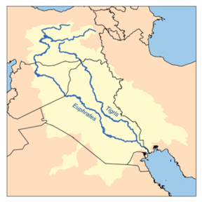
The Euphrates River is the western of the two great rivers that define Mesopotamia, the other being the Tigris River. The two rivers have their sources within 50 miles of each other in eastern Turkey and travel southeast through northern Syria and Iraq to the head of the Persian Gulf.
They form a great river system, an alluvial salt marsh ecoregion of the Middle East. The rivers have several small tributaries which feed into shallow freshwater lakes, swamps, and marshes, all surrounded by desert. The hydrology of these vast marshes is extremely important to the ecology of the entire upper Persian Gulf, in an area called the Cradle of Civilization due to its ancient history.
The Euphrates River has numerous mentions in the Judeo–Christian Bible as well as in the hadiths of the Prophet Muhammad.
Source
The Euphrates is the largest river in Southwest Asia, 1,730 miles (2,781 kilometers) long. It is formed by the confluence of two branches, the Karasu River, (which rises in the Armenian Highlands of today's eastern Turkey north of Erzurum) and the Murat River, (which issues from an area southwest of Mount Ararat, north of Lake Van). It descends between major ranges of the Taurus Mountains.
Though less than 30 percent of its drainage basin is in Turkey, it receives approximately 94 percent of its water while within the Turkish highlands.
Course

The upper reaches of the Euphrates flow through steep canyons and gorges, southeast across Syria, and through Iraq. The Khabur, a major tributary originating in southeastern Turkey, and the Balikh River join the Euphrates in eastern Syria. They are the only two tributaries of the Euphrates.
Downstream, through its whole length, the Euphrates receives no further water flow. North of Basra, in southern Iraq, the river merges with the Tigris to form the Shatt al-Arab, this in turn empties into the Persian Gulf.
In ancient times the river's valley was heavily irrigated and many great cities rose on its banks. The ruins of some of these communities remain.
Geography
The general climate of the River area is subtropical, hot, and arid. At the northern end of the Persian Gulf is the vast floodplain of the Euphrates, Tigris, and Karun Rivers, featuring huge permanent lakes, marshes, and forest.
The aquatic vegetation includes reeds, rushes, and papyrus, which support numerous species. Areas around the Tigris and the Euphrates are very fertile. Marshy land is home to water birds, some stopping here while migrating, and some spending the winter in these marshes living off the lizards, snakes, frogs, and fish. Other animals found in these marshes are water buffalo, two endemic rodent species, antelopes and gazelles and small animals such as the jerboa and several other mammals.
Concerns
At one time the river divided into many channels at Basra, forming an extensive marshland. A fine and extensive natural wetlands ecosystem, they developed over thousands of years in the Tigris-Euphrates basin and once covered 15,000-20,000 square kilometers. According to the United Nations Environmental Program and the AMAR Charitable Foundation, between 84 percent and 90 percent of the marshes have been destroyed since the 1970s. In 1994, 60 percent of the wetlands were destroyed by Saddam Hussein's regime. They were drained to permit military access and greater political control of the native Marsh Arabs.
Canals, dykes, and dams were built routing the water of the Tigris and Euphrates Rivers around the marshes, instead of allowing water to move slowly through the marshland. After part of the Euphrates was dried up due to re-routing its water to the sea, a dam was built so water could not back up from the Tigris and sustain the former marshland. Some marshlands were burned and buried pipes underground helped to carry away water for quicker drying.
The drying of the marshes lead to the disappearance of the salt-tolerant vegetation, the plankton rich waters that fertilized surrounding soils, 52 native fish species, the wild boar, Red Fox, buffalo and water birds of the marsh habitat. Since the 2003 U.S. invasion of Iraq, the drainage policy has been reversed, but it remains to be seen whether the marshes will recover.
As with the Tigris, there is much controversy over rights and use of the river. The Southeastern Anatolia Project in Turkey involves the construction of 22 dams and 19 power plants the biggest development project ever undertaken by Turkey. The Turkish authorities hope that the project will provide a boost to the region's economy, but domestic and foreign critics have disputed its benefits as well as attacking the social and environmental costs of the scheme.
In Syria the Tabaqah Dam (completed in 1973 and sometimes known simply as the Euphrates Dam) forms a reservoir, Lake Assad, that is used for irrigating cotton. Syria has dammed its two tributaries and is in the process of constructing another dam. Iraq has seven dams in operation, but water control lost priority during Saddam Hussein's regime. Since the collapse of Ba'ath Iraq in 2003, water use has come once again to the fore. The scarcity of water in the Middle East leaves Iraq in constant fear that Syria and Turkey will use most of the water before it reaches Iraq. As it is, irrigation in southern Iraq leaves little water to join the Tigris at the Shatt-al-Arab.
Euphrates in the Bible
A river named Perath (Hebrew for Euphrates) is one of the four rivers that flow from the Garden of Eden according to Genesis 2:14. This Hebrew word, derived from either the word "stream" or "to break forth," has been translated as Euphrates. It is the fourth river, after the Pishon, the Gihon, and the Tigris, (Hebrew name is Hiddekel) to form from the river flowing out of the Garden.
The river of the same name marked one of the boundaries of the land promised by God to Abraham and his descendants through Isaac and Jacob. In the Hebrew Bible, it is often referred to simply as "The River" (ha-nahar); "On that day the Lord made a covenant with Abram and said, "To your descendants I give this land, from the river of Egypt to the great river, the Euphrates" (Genesis 15:18 NIV).
- God creates the Euphrates: "The name of the third river is Tigris, the one that flows east of Asshur. And the fourth river is the Euphrates" (Genesis 2:14).
- The Euphrates marks the north-eastern border of the land God promises to Abram: "To your descendants I give this land from the wadi of Egypt to the Great River, the river Euphrates" (Genesis 15:18 in the Jerusalem Bible)
- God tells the Israelites to go to the Promised Land: "Start out and make your way to the hill country of the Amorites and to all their neighbors in the Arabah, the hill country, the Shephelah, the Negeb, the seacoast, the land of the Canaanites, and the Lebanon, as far as the Great River, the river Euphrates" (Deuteronomy 1:7).
- God (through Moses) promises the Israelites the Promised Land: "Every place where you set the soles of your feet shall be yours. Your borders shall run from the wilderness to the Lebanon and from the River, the river Euphrates, to the western sea" (Deuteronomy 11:24).
- In Revelation 16:12, it is prophesied that the Euphrates will dry up in preparation for the Battle of Armageddon: "And the sixth angel poured out his vial upon the great river Euphrates; and the water thereof was dried up, that the way of the kings of the east might be prepared."
Islamic prophecies
In Islam, some of the hadiths of the Prophet Muhammad suggest that the Euphrates will dry up, revealing unknown treasures that will be the cause of strife and war.
- Soon the river Euphrates will disclose the treasure [the mountain] of gold. So, whoever will be present at that time should not take anything of it.—Sahih Bukhari.
- The Prophet Muhammad said: "The Hour will not come to pass before the river Euphrates dries up to unveil the mountain of gold, for which people will fight. Ninety-nine out of one hundred will die [in the fighting], and every man among them will say: 'Perhaps I may be the only one to remain alive'."—Sahih Bukhari, Sahih Muslim.
- The Prophet Muhammad said: "The Euphrates reveals the treasures within itself. Whoever sees it should not take anything from it".—Al-Muttaqi al-Hindi, Al-Burhan fi `Alamat al-Mahdi Akhir az-Zaman, p. 28.
- It [the Euphrates] will uncover a mountain of gold [under it].—Sunan Abi Da'ud.
Euphrates in history
The Euphrates provided the water that led to the first flowering of civilization in Sumer, dating from about the fourth millennium B.C.E. Many important ancient cities were located on or near the riverside, including Mari, Sippar, Nippur, Shuruppak, Uruk, Ur, and Eridu.
The river valley formed the heartlands of the later empires of Babylonia and Assyria. For several centuries, the river formed the eastern limit of effective Egyptian and Roman control and western regions of the Persian Empire.
Also, the Battle of Karbala, a defining moment in Islamic history, when Imam Hussain, along with his family and friends were martyred, occurred at the banks of Euphrates River.
References
ISBN links support NWE through referral fees
- Batchelor, John, and Julie Batchelor. 1981. The Euphrates. Rivers of the world. Hove, East Sussex: Wayland. ISBN 0382065182 ISBN 9780382065187
- Euphrates. ChristianAnswers.Net, 2008. Retrieved November 24, 2007.
- Kolars, John F., and William A. Mitchell. 1991. The Euphrates River and the Southeast Anatolia Development Project. Water, the Middle East imperative. Carbondale: Southern Illinois University Press. ISBN 0809315726 ISBN 9780809315727
- Mountjoy, Shane. 2005. The Tigris & Euphrates river [i.e. rivers]. Rivers in world history. Philadelphia, PA: Chelsea House. ISBN 0791082466 and ISBN 9780791082461
- Peltenburg, E. J. 2007. Euphrates River Valley settlement the Carchemish sector in the third millennium B.C.E.. Levant supplementary series, v. 5. Oxford: Oxbow Books. ISBN 9781842172728 and ISBN 1842172727
- Salīm, Shākir Muṣţafā. 1962. Marsh dwellers of the Euphrates Delta. [London]: University of London, Athlone Press.
External links
All links retrieved August 12, 2017.
- Euphrates – Jewish Encyclopedia.
Credits
New World Encyclopedia writers and editors rewrote and completed the Wikipedia article in accordance with New World Encyclopedia standards. This article abides by terms of the Creative Commons CC-by-sa 3.0 License (CC-by-sa), which may be used and disseminated with proper attribution. Credit is due under the terms of this license that can reference both the New World Encyclopedia contributors and the selfless volunteer contributors of the Wikimedia Foundation. To cite this article click here for a list of acceptable citing formats.The history of earlier contributions by wikipedians is accessible to researchers here:
The history of this article since it was imported to New World Encyclopedia:
Note: Some restrictions may apply to use of individual images which are separately licensed.
↧ Download as ZWI file | Last modified: 02/04/2023 13:31:29 | 147 views
☰ Source: https://www.newworldencyclopedia.org/entry/Euphrates_river | License: CC BY-SA 3.0
 ZWI signed:


 KSF
KSF