Caves Of Hotton
 From Handwiki
 Short description: Speleothem caves near Hotton in Belgium
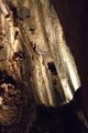
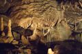
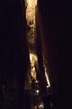
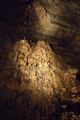
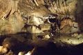
The Caves of Hotton are speleothem caves located in Wallonia near Hotton in Belgium, which were discovered in 1958 and are around 5 or 6 km long and 70 metres deep.[1][2] A stream called Syphon runs at the bottom of the caves.
Gallery
References
- ↑ J.F. Cadorin,D. Jongmans,A. Plumier,T. Camelbeeck, S. Delaby, Y. Quinif. Modelling of speleothems failure in the Hotton cave (Belgium). Is the failure earthquake induced? Netherlands Journal of Geosciences / Geologie en Mijnbouw 80 (3-4): 315-321 (2001).
- ↑ Ardennes-etape.com: The Caves of Hotton
External links
- Hotton's Caves (incl. cave map and images)
[ ⚑ ] 50°15′33″N 5°27′21″E / 50.2592°N 5.4559°E
 |  |
Categories: [Limestone caves]
↧ Download as ZWI file | Last modified: 08/10/2024 01:50:44 | 4 views
☰ Source: https://handwiki.org/wiki/Earth:Caves_of_Hotton | License: CC BY-SA 3.0
✘
ZWI is not signed. [what is this?]
ZWI viewer
by the  KSF
KSF