Landmass
 From Handwiki
A landmass, or land mass, is a large region or area of land that is in one piece and not broken up by oceans.[1][2] The term is often used to refer to lands surrounded by an ocean or sea, such as a continent or a large island.[3][4] In the field of geology, a landmass is a defined section of continental crust extending above sea level.[5]
Continents are often thought of as distinct landmasses and may include any islands that are part of the associated continental shelf. When multiple continents form a single contiguous land connection, the connected continents may be viewed as a single landmass. Earth's largest landmasses are (starting with largest):[6][7][8]
- Afro-Eurasia (main landmass of the geoscheme region of the same name and its continental parts Africa and Eurasia - or Europe and Asia; the center of Earth's land hemisphere, comprising more than half of Earth's landmass)
- Americas (main landmass of the geo-region of the same name and its continental parts North and South America; comprising most of the landmass of the Western Hemisphere)
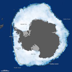
- Antarctica (main landmass of the geo-region and continent of the same name)
- Mainland Australia (main landmass of the geo-region Oceania, its sub-region Australasia, the continent Australia and the country Australia )
See also
- Coastline paradox
- Continent
- Boundaries between the continents of Earth
- Island
- List of islands by area
- Landform
- Glossary of landforms
- Mainland
- Supercontinent
References
- ↑ "Landmass". Cambridge.org Dictionary. https://dictionary.cambridge.org/dictionary/english/landmass.
- ↑ "Landmass". Merriam-Webster.com Dictionary. https://www.merriam-webster.com/dictionary/landmass.
- ↑ Cook, Peter J.; Carleton, Chris M., eds (9 November 2000). Continental Shelf Limits: The Scientific and Legal Interface. Oxford University Press. p. 298. doi:10.1093/oso/9780195117820.001.0001. ISBN 9780197561218. https://books.google.com/books?id=ABVfvyi-8IAC&dq=continent+island+landmass&pg=PA298.
- ↑ Nijman, Jan; Muller, Peter O.; de Blij, H.J. (2017). "Introduction". Regions: Geography: Realms, Regions, and Concepts (17th ed.). Wiley. p. 11. ISBN 978-1-119-30189-9.
- ↑ "Landmass". Dictionary.com, LLC. https://www.dictionary.com/browse/landmass?s=t.
- ↑ Dempsey, Caitlin (2013-10-15). "Geography Facts about the World's Continents". https://www.geographyrealm.com/continents/.
- ↑ Dunn, Ross E.; Mitchell, Laura J.; Ward, Kerry (23 August 2016). The New World History: A Field Guide for Teachers and Researchers. University of California Press. pp. 232–. ISBN 978-0-520-28989-5. https://books.google.com/books?id=-aowDwAAQBAJ&pg=PA232.
- ↑ R.W. McColl, ed (2005). "continents". Encyclopedia of World Geography. 1. Facts on File, Inc.. p. 215. ISBN 978-0-8160-7229-3. https://books.google.com/books?id=DJgnebGbAB8C&pg=PA215. Retrieved 25 August 2022. "And since Africa and Asia are connected at the Suez Peninsula, Europe, Africa, and Asia are sometimes combined as Afro-Eurasia or Eurafrasia. The International Olympic Committee's official flag, containing [...] the single continent of America (North and South America being connected as the Isthmus of Panama).".
Lua error in package.lua at line 80: module 'Module:Portal/images/g' not found.
{{Navbox | name = Geography topics | state = collapsed | title = Geography topics | bodyclass = hlist
| above =
- History
- Index
- Outline
| group1 = Branches | list1 =
 {{Navbox|child
 | bodyclass = hlist
 | group1 = Human
 | list1  =
- Agricultural
- Behavioral
- Cultural
- Development
- Economic
- Health
- Historical
- Political
- Population
- Settlement
- Regional
- Urban
 | group2 = Physical
 | list2  =
- Biogeography
- Ecology
- Phytogeography
- Zoogeography
- Coastal / Oceanography
- Earth science
- Atmospheric science / Meteorology
- Environmental science
- Climatology / Paleoclimatology / Palaeogeography
- Geobiology
- Geophysics / Geodesy
- Earth system science
- Geomorphology / Geology
- Glaciology
- [[Earth:HydrologHydrology / Limnology
- Pedology (Edaphology/Soil science)
- Quaternary science
 | group3 = Integrated
 | list3  =
- Integrated / Environmental
- Environmental social science
- Environmental studies
- Landscape architecture
- Landscape ecology
- Time geography
}}
| group2 = Techniques and tools | list2 =
- Geoinformatics / Geomathematics
- Cartography
- Geologic modelling
- Geostatistics
- Geographic information system
- Geochronology
- Geomatics
- Hydrography
- Photogrammetry
- Remote sensing
- Land change modeling
| group3 = Institutions | list3 =
- Geographic data and information organizations
- Geographical societies
- Geoscience societies
- National mapping agency
| group4 = Education | list4 =
- Geography education
- Geo-literacy
- International Geography Olympiad
- Spatial citizenship
| below =
 Category
 Portal
 Commons
 WikiProject
}}
Geology | ||
|---|---|---|
| Overviews |
| Error creating thumbnail: Unable to save thumbnail to destination |
| History of geology |
| |
| Сomposition and structure |
| |
| Historical geology |
| |
| Motion |
| |
| Water |
| |
| Geophysics |
| |
| Applications |
| |
| Occupations |
| |
| ||
 |  |
Categories: [Landforms] [Geography terminology] [Geology terminology]
↧ Download as ZWI file | Last modified: 11/06/2025 15:37:02 | 14 views
☰ Source: https://handwiki.org/wiki/Earth:Landmass | License: CC BY-SA 3.0