Eye (Cyclone)
 From Handwiki
| Part of a series on |
| Tropical cyclones |
|---|
|
Outline of tropical cyclones |
The eye is a region of mostly calm weather at the center of a tropical cyclone. The eye of a storm is a roughly circular area, typically 30–65 kilometers (19–40 miles) in diameter. It is surrounded by the eyewall, a ring of towering thunderstorms where the most severe weather and highest winds of the cyclone occur. The cyclone's lowest barometric pressure occurs in the eye and can be as much as 15 percent lower than the pressure outside the storm.[1]
In strong tropical cyclones, the eye is characterized by light winds and clear skies, surrounded on all sides by a towering, symmetric eyewall. In weaker tropical cyclones, the eye is less well defined and can be covered by the central dense overcast, an area of high, thick clouds that show up brightly on satellite imagery. Weaker or disorganized storms may also feature an eyewall that does not completely encircle the eye or have an eye that features heavy rain. In all storms, however, the eye is where the barometer reading is lowest.[1][2]
Structure
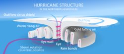
A typical tropical cyclone has an eye approximately 30–65 km (20–40 mi) across at the geometric center of the storm. The eye may be clear or have spotty low clouds (a clear eye), it may be filled with low- and mid-level clouds (a filled eye), or it may be obscured by the central dense overcast. There is, however, very little wind and rain, especially near the center. This is in stark contrast to conditions in the eyewall, which contains the storm's strongest winds.[3] Due to the mechanics of a tropical cyclone, the eye and the air directly above it are warmer than their surroundings.[4]
While normally quite symmetric, eyes can be oblong and irregular, especially in weakening storms. A large ragged eye is a non-circular eye which appears fragmented, and is an indicator of a weak or weakening tropical cyclone. An open eye is an eye which can be circular, but the eyewall does not completely encircle the eye, also indicating a weakening, moisture-deprived cyclone or a weak but strengthening one. Both of these observations are used to estimate the intensity of tropical cyclones via Dvorak analysis.[5] Eyewalls are typically circular; however, distinctly polygonal shapes ranging from triangles to hexagons occasionally occur.[6]
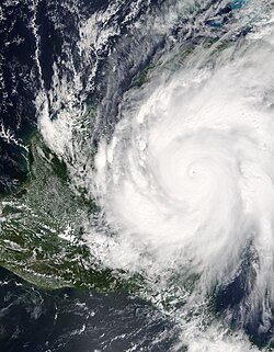
While typical mature storms have eyes that are a few dozen miles across, rapidly intensifying storms can develop an extremely small, clear, and circular eye, sometimes referred to as a pinhole eye. Storms with pinhole eyes are prone to large fluctuations in intensity, and provide difficulties and frustrations for forecasters.[7]
.jpg)
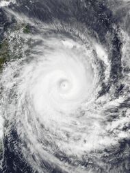
Small/minuscule eyes – those less than ten nautical miles (19 km, 12 mi) across – often trigger eyewall replacement cycles, where a new eyewall begins to form outside the original eyewall. This can take place anywhere from fifteen to hundreds of kilometers (ten to a few hundred miles) outside the inner eye. The storm then develops two concentric eyewalls, or an "eye within an eye". In most cases, the outer eyewall begins to contract soon after its formation, which chokes off the inner eye and leaves a much larger but more stable eye. While the replacement cycle tends to weaken storms as it occurs, the new eyewall can contract fairly quickly after the old eyewall dissipates, allowing the storm to re-strengthen. This may trigger another re-strengthening cycle of eyewall replacement.[8]
Eyes can range in size from 370 km (230 mi) (Typhoon Carmen)[9] to a mere 3.7 km (2.3 mi) (Hurricane Wilma) across.[10] While it is uncommon for storms with large eyes to become very intense, it does occur, especially in annular hurricanes. Hurricane Isabel was the eleventh most powerful North Atlantic hurricane in recorded history, and sustained a wide – 65–80 km (40–50 mi) – eye for a period of several days.[11]
Formation and detection


Tropical cyclones typically form from large, disorganized areas of disturbed weather in tropical regions. As more thunderstorms form and gather, the storm develops rainbands which start rotating around a common center. As the storm gains strength, a ring of stronger convection forms at a certain distance from the rotational center of the developing storm. Since stronger thunderstorms and heavier rain mark areas of stronger updrafts, the barometric pressure at the surface begins to drop, and air begins to build up in the upper levels of the cyclone.[12] This results in the formation of an upper level anticyclone, or an area of high atmospheric pressure above the central dense overcast. Consequently, most of this built up air flows outward anticyclonically above the tropical cyclone. Outside the forming eye, the anticyclone at the upper levels of the atmosphere enhances the flow towards the center of the cyclone, pushing air towards the eyewall and causing a positive feedback loop.[12]
However, a small portion of the built-up air, instead of flowing outward, flows inward towards the center of the storm. This causes air pressure to build even further, to the point where the weight of the air counteracts the strength of the updrafts in the center of the storm. Air begins to descend in the center of the storm, creating a mostly rain-free area – a newly formed eye.[12]
Many aspects of this process remain a mystery. Scientists do not know why a ring of convection forms around the center of circulation instead of on top of it, or why the upper-level anticyclone ejects only a portion of the excess air above the storm. Many theories exist as to the exact process by which the eye forms: all that is known for sure is that the eye is necessary for tropical cyclones to achieve high wind speeds.[12]
The formation of an eye is almost always an indicator of increasing tropical cyclone organisation and strength. Because of this, forecasters watch developing storms closely for signs of eye formation.[citation needed]
For storms with a clear eye, detection of the eye is as simple as looking at pictures from a weather satellite. However, for storms with a filled eye, or an eye completely covered by the central dense overcast, other detection methods must be used. Observations from ships and hurricane hunters can pinpoint an eye visually, by looking for a drop in wind speed or lack of rainfall in the storm's center. In the United States, South Korea, and a few other countries, a network of NEXRAD Doppler weather radar stations can detect eyes near the coast. Weather satellites also carry equipment for measuring atmospheric water vapor and cloud temperatures, which can be used to spot a forming eye. In addition, scientists have recently discovered that the amount of ozone in the eye is much higher than the amount in the eyewall, due to air sinking from the ozone-rich stratosphere. Instruments sensitive to ozone perform measurements, which are used to observe rising and sinking columns of air, and provide indication of the formation of an eye, even before satellite imagery can determine its formation.[13]
One satellite study found eyes detected on average for 30 hours per storm.[14]
Associated phenomena
Eyewall replacement cycles
Eyewall replacement cycles, also called concentric eyewall cycles, naturally occur in intense tropical cyclones, generally with winds greater than 185 km/h (115 mph), or major hurricanes (Category 3 or higher on the Saffir–Simpson hurricane scale). When tropical cyclones reach this intensity, and the eyewall contracts or is already sufficiently small (see above), some of the outer rainbands may strengthen and organize into a ring of thunderstorms – an outer eyewall – that slowly moves inward and robs the inner eyewall of its needed moisture and angular momentum. Since the strongest winds are located in a cyclone's eyewall, the tropical cyclone usually weakens during this phase, as the inner wall is "choked" by the outer wall. Eventually the outer eyewall replaces the inner one completely, and the storm can re-intensify.[8]
The discovery of this process was partially responsible for the end of the U.S. government's hurricane modification experiment Project Stormfury. This project set out to seed clouds outside the eyewall, causing a new eyewall to form and weakening the storm. When it was discovered that this was a natural process due to hurricane dynamics, the project was quickly abandoned.[8]
Research shows that 53 percent of intense hurricanes undergo at least one of these cycles during its existence.[15] Hurricane Allen in 1980 went through repeated eyewall replacement cycles, fluctuating between Category 5 and Category 4 status on the Saffir–Simpson scale several times, while Hurricane Juliette (2001) is a documented case of triple eyewalls.[15]
Moats
A moat in a tropical cyclone is a clear ring outside the eyewall, or between concentric eyewalls, characterized by subsidence (slowly sinking air) and little or no precipitation. The air flow in the moat is dominated by the cumulative effects of stretching and shearing. The moat between eyewalls is an area in the storm where the rotational speed of the air changes greatly in proportion to the distance from the storm's center; these areas are also known as rapid filamentation zones. Such areas can potentially be found near any vortex of sufficient strength, but are most pronounced in strong tropical cyclones.[16]
Eyewall mesovortices
_eye_close-up.jpg)
Eyewall mesovortices are small scale rotational features found in the eyewalls of intense tropical cyclones. They are similar, in principle, to small "suction vortices" often observed in multiple-vortex tornadoes.[17] In these vortices, wind speeds may be greater than anywhere else in the eyewall.[18] Eyewall mesovortices are most common during periods of intensification in tropical cyclones.[17]
Eyewall mesovortices often exhibit unusual behavior in tropical cyclones. They usually revolve around the low pressure center, but sometimes they remain stationary. Eyewall mesovortices have even been documented to cross the eye of a storm. These phenomena have been documented observationally,[19] experimentally,[17] and theoretically.[20]
Eyewall mesovortices are a significant factor in the formation of tornadoes after tropical cyclone landfall. Mesovortices can spawn rotation in individual convective cells or updrafts (a mesocyclone), which leads to tornadic activity. At landfall, friction is generated between the circulation of the tropical cyclone and land. This can allow the mesovortices to descend to the surface, causing tornadoes.[21] These tornadic circulations in the boundary layer may be prevalent in the inner eyewalls of intense tropical cyclones but with short duration and small size they are not frequently observed.[22]
Stadium effect
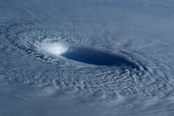
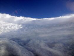
The stadium effect is a phenomenon observed in strong tropical cyclones. It is a fairly common event, where the clouds of the eyewall curve outward from the surface with height. This gives the eye an appearance resembling a sports stadium from the air. An eye is always larger at the top of the storm, and smallest at the bottom of the storm because the rising air in the eyewall follows isolines of equal angular momentum, which also slope outward with height.[23][24][25]
Eye-like features
An eye-like structure is often found in intensifying tropical cyclones. Similar to the eye seen in hurricanes or typhoons, it is a circular area at the circulation center of the storm in which convection is absent. These eye-like features are most normally found in intensifying tropical storms and hurricanes of Category 1 strength on the Saffir-Simpson scale. For example, an eye-like feature was found in Hurricane Beta when the storm had maximum wind speeds of only 80 km/h (50 mph), well below hurricane force.[26] The features are typically not visible on visible wavelengths or infrared wavelengths from space, although they are easily seen on microwave satellite imagery.[27] Their development at the middle levels of the atmosphere is similar to the formation of a complete eye, but the features might be horizontally displaced due to vertical wind shear.[28][29]
Hazards
File:Flying through a storm's eyewall and into the calm eye.ogv
Though the eye is by far the calmest part of the storm (at least on land), with no wind at the center and typically clear skies, on the ocean it is possibly the most hazardous area. In the eyewall, wind-driven waves all travel in the same direction. In the center of the eye, however, the waves converge from all directions, creating erratic crests that can build on each other to become rogue waves. The maximum height of hurricane waves is unknown, but measurements during Hurricane Ivan when it was a Category 4 hurricane estimated that waves near the eyewall exceeded 40 m (130 ft) from peak to trough.[30]
A common mistake, especially in areas where hurricanes are uncommon, is for residents to exit their homes to inspect the damage while the calm eye passes over, only to be caught off guard by the violent winds in the opposite eyewall.[31]
Other cyclones
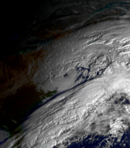
Though only tropical cyclones have structures officially termed "eyes", there are other weather systems that can exhibit eye-like features.[1][32]
Polar lows
Polar lows are mesoscale weather systems, typically smaller than 1,000 km (600 mi) across, found near the poles. Like tropical cyclones, they form over relatively warm water and can feature deep convection and winds of gale force or greater. Unlike storms of tropical nature, however, they thrive in much colder temperatures and at much higher latitudes. They are also smaller and last for shorter durations, with few lasting longer than a day or so. Despite these differences, they can be very similar in structure to tropical cyclones, featuring a clear eye surrounded by an eyewall and bands of rain and snow.[33]
Extratropical cyclones
Extratropical cyclones are areas of low pressure which exist at the boundary of different air masses. Almost all storms found at mid-latitudes are extratropical in nature, including classic North American nor'easters and European windstorms. The most severe of these can have a clear "eye" at the site of lowest barometric pressure, though it is usually surrounded by lower, non-convective clouds and is found near the back end of the storm.[34]
Subtropical cyclones
Subtropical cyclones are low-pressure systems with some extratropical characteristics and some tropical characteristics. As such, they may have an eye while not being truly tropical in nature. Subtropical cyclones can be very hazardous, generating high winds and seas, and often evolve into fully tropical cyclones. For this reason, the National Hurricane Center began including subtropical storms in its naming scheme in 2002.[35]
Tornadoes
Tornadoes are destructive, small-scale storms, which produce the fastest winds on earth. There are two main types: single-vortex tornadoes, which consist of a single spinning column of air, and multiple-vortex tornadoes, which consist of small "suction vortices," resembling mini-tornadoes themselves, all rotating around a common center. Both of these types of tornadoes are theorized to have calm eyes. These theories are supported by doppler velocity observations by weather radar and eyewitness accounts.[36][37]
Extraterrestrial vortices
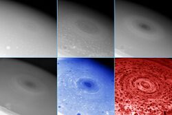
NASA reported in November 2006 that the Cassini spacecraft observed a "hurricane-like" storm locked to the south pole of Saturn with a clearly defined eyewall. The observation was particularly notable as eyewall clouds had not previously been seen on any planet other than Earth (including a failure to observe an eyewall in the Great Red Spot of Jupiter by the Galileo spacecraft).[38] In 2007, very large vortices on both poles of Venus were observed by the Venus Express mission of the European Space Agency to have a dipole eye structure.[39]
See also
- Outline of tropical cyclones
- Radius of maximum wind
- RAINEX
- Storm surge
- Eyewall replacement cycle
References
- ↑ 1.0 1.1 1.2 Landsea, Chris; Goldenberg, Stan (2012-06-01). "A: Basic definitions". in Dorst, Neal. Frequently Asked Questions (FAQ). Atlantic Oceanographic and Meteorological Laboratory. pp. A11: What is the 'eye'?. http://www.aoml.noaa.gov/hrd/tcfaq/tcfaqA.html.
- ↑ Landsea, Chris; Goldenberg, Stan (2012-06-01). "A: Basic definitions". in Dorst, Neal. Frequently Asked Questions (FAQ). Atlantic Oceanographic and Meteorological Laboratory. pp. A9: What is a "CDO"?. http://www.aoml.noaa.gov/hrd/tcfaq/tcfaqA.html.
- ↑ "Tropical Cyclone Structure". JetStream – Online School for Weather. National Weather Service. 2010-01-05. http://www.srh.noaa.gov/jetstream/tropics/tc_structure.htm.
- ↑ Landsea, Chris; Goldenberg, Stan (2012-06-01). "A: Basic definitions". in Dorst, Neal. Frequently Asked Questions (FAQ). Atlantic Oceanographic and Meteorological Laboratory. pp. A7: What is an extra-tropical cyclone?. http://www.aoml.noaa.gov/hrd/tcfaq/tcfaqA.html.
- ↑ Velden, Christopher S.; Olander, Timothy L.; Zehr, Raymond M. (1998). "Development of an Objective Scheme to Estimate Tropical Cyclone Intensity from Digital Geostationary Satellite Infrared Imagery". Weather and Forecasting 13 (1): 172–173. doi:2.0.CO;2">10.1175/1520-0434(1998)013<0172:DOAOST>2.0.CO;2. Bibcode: 1998WtFor..13..172V.
- ↑ Schubert, Wayne H. (1999). "Polygonal Eyewalls, Asymmetric Eye Contraction, and Potential Vorticity Mixing in Hurricanes". Journal of the Atmospheric Sciences 59 (9): 1197–1223. doi:2.0.CO;2">10.1175/1520-0469(1999)056<1197:PEAECA>2.0.CO;2. Bibcode: 1999JAtS...56.1197S.
- ↑ Beven, Jack (2005-10-08). Hurricane Wilma Advisory Archive (Report). National Hurricane Center. http://www.nhc.noaa.gov/archive/2005/WILMA.shtml?. Retrieved 2013-05-06.
- ↑ 8.0 8.1 8.2 Landsea, Chris; Goldenberg, Stan (2012-06-01). "D: Tropical cyclone winds and energy". in Dorst, Neal. Frequently Asked Questions (FAQ). Atlantic Oceanographic and Meteorological Laboratory. pp. D8: What are "concentric eyewall cycles"?. http://www.aoml.noaa.gov/hrd/tcfaq/tcfaqD.html.
- ↑ Evans, Bill (2012-05-22). It's Raining Fish and Spiders. Hurricane Extremes: Google Ebooks. ISBN 9781429984829. https://books.google.com/books?id=Buth_mZz8W8C&q=typhoon+carmen+largest+eye&pg=PT6. Retrieved 20 August 2015.
- ↑ A Dictionary of Weather. Weather Records: Storm Dunlop. 2008-08-14. ISBN 9780191580055. https://books.google.com/books?id=27DdCC-nSCEC&q=hurricane+wilma+smallest+eye+3.7+km\&pg=PT219. Retrieved 20 August 2015.
- ↑ Beven, Jack; Cobb, Hugh (2003). Hurricane Isabel: 6–19 September 2003 (Tropical Cyclone Report). National Hurricane Center. http://www.nhc.noaa.gov/2003isabel.shtml?. Retrieved 2013-05-06.
- ↑ 12.0 12.1 12.2 12.3 Vigh, Jonathan (2006). "Formation of the Hurricane Eye". 27th Conference on Hurricanes and Tropical Meteorology. Monterey, California: American Meteorological Society. http://ams.confex.com/ams/pdfpapers/108319.pdf. Retrieved 2013-05-07.
- ↑ Gutro, Rob (2005-06-08). "Ozone Levels Drop When Hurricanes Are Strengthening" (Press release). NASA. Archived from the original on 2012-11-05. Retrieved 2013-05-06.
- ↑ Knapp, Kenneth R.; C. S. Velden; A. J. Wimmers (2018). "A Global Climatology of Tropical Cyclone Eyes". Mon. Wea. Rev. 146 (7): 2089–2101. doi:10.1175/MWR-D-17-0343.1. Bibcode: 2018MWRv..146.2089K.
- ↑ 15.0 15.1 McNoldy, Brian D. (2004). "Triple Eyewall in Hurricane Juliette". Bulletin of the American Meteorological Society 85 (11): 1663–1666. doi:10.1175/BAMS-85-11-1663. Bibcode: 2004BAMS...85.1663M. http://andrew.rsmas.miami.edu/bmcnoldy/papers/M2004_BAMS.pdf. Retrieved 2018-03-10.
- ↑ Rozoff, Christopher M.; Schubert, Wayne H.; McNoldy, Brian D.; Kossin, James P. (2006). "Rapid filamentation zones in intense tropical cyclones". Journal of the Atmospheric Sciences 63 (1): 325–340. doi:10.1175/JAS3595.1. Bibcode: 2006JAtS...63..325R.
- ↑ 17.0 17.1 17.2 Montgomery, Michael T.; Vladimirov, Vladimir A.; Denissenko, Peter V. (2002). "An experimental study on hurricane mesovortices". Journal of Fluid Mechanics 471 (1): 1–32. doi:10.1017/S0022112002001647. Bibcode: 2002JFM...471....1M. http://www.met.nps.edu/~mtmontgo/papers/hurricane_mesovortices.pdf. Retrieved 2013-05-06.
- ↑ Aberson, Sim D.; Black, Michael L.; Montgomery, Michael T.; Bell, Michael (2004). "A Record Wind Measurement in Hurricane Isabel: Direct Evidence of an Eyewall Mesocyclone?". 26th Conference on Hurricanes and Tropical Meteorology. Miami, Florida: American Meteorological Society. https://ams.confex.com/ams/pdfpapers/75718.pdf. Retrieved 2013-05-07.
- ↑ Kossin, James P.; McNoldy, Brian D.; Schubert, Wayne H. (2002). "Vortical swirls in hurricane eye clouds". Monthly Weather Review 130 (12): 3144–3149. doi:2.0.CO;2">10.1175/1520-0493(2002)130<3144:VSIHEC>2.0.CO;2. Bibcode: 2002MWRv..130.3144K.
- ↑ Kossin, James. P.; Schubert, Wayne H. (2001). "Mesovortices, polygonal flow patterns, and rapid pressure falls in hurricane-like vortices". Journal of the Atmospheric Sciences 58 (15): 2196–2209. doi:2.0.CO;2">10.1175/1520-0469(2001)058<2196:MPFPAR>2.0.CO;2. Bibcode: 2001JAtS...58.2196K.
- ↑ Wright, John E.; Bennett, Shawn P. (2009-01-16). "Meso-Vortices Observed By WSR-88D In The Eye" (Press release). National Weather Service. Archived from the original on 2013-05-15. Retrieved 2013-05-07.
- ↑ Wu, Liguang; Q. Liu; Y. Li (2018). "Prevalence of tornado-scale vortices in the tropical cyclone eyewall". Proc. Natl. Acad. Sci. U.S.A. 115 (33): 8307–8310. doi:10.1073/pnas.1807217115. PMID 30061409. Bibcode: 2018PNAS..115.8307W.
- ↑ Hawkins, Harry F.; Rubsam, Daryl T. (1968). "Hurricane Hilda, 1964: II. Structure and budgets of the hurricane on October 1, 1964". Monthly Weather Review 96 (9): 617–636. doi:2.0.CO;2">10.1175/1520-0493(1968)096<0617:HH>2.0.CO;2. Bibcode: 1968MWRv...96..617H.
- ↑ Gray, W. M.; Shea, D. J. (1973). "The hurricane's inner core region: II. Thermal stability and dynamic characteristics". Journal of the Atmospheric Sciences 30 (8): 1565–1576. doi:2.0.CO;2">10.1175/1520-0469(1973)030<1565:THICRI>2.0.CO;2. Bibcode: 1973JAtS...30.1565G.
- ↑ Hawkins, Harry F.; Imbembo, Stephen M. (1976). "The structure of a Small, Intense Hurricane – Inez 1966". Monthly Weather Review 104 (4): 418–442. doi:2.0.CO;2">10.1175/1520-0493(1976)104<0418:TSOASI>2.0.CO;2. Bibcode: 1976MWRv..104..418H.
- ↑ Beven, John L. (2005-10-27). Hurricane Beta Advisory Archive (Report). National Hurricane Center. http://www.nhc.noaa.gov/archive/2005/BETA.shtml?. Retrieved 2013-05-07.
- ↑ Marks, Frank D.; Stewart, Stacy R. (2001). "TRMM Satellite Data – Applications to Tropical Cyclone Analysis and Forecasting". TRMM Workshops. Boulder, Colorado: University Corporation for Atmospheric Research. pp. 7–25. http://www.isse.ucar.edu/trmm/presentations/marks.pdf. Retrieved 2013-05-07.
- ↑ "STORM project" (Press release). National Weather Service. Archived from the original on 2008-09-27. Retrieved 2008-03-12.
- ↑ Brown, Daniel; Roberts, Dave. "Interpretation of passive microwave imagery" (Press release). National Oceanic and Atmospheric Administration. Archived from the original on 2008-09-27. Retrieved 2008-03-12.
- ↑ Wang, David W.; Mitchell, Douglas A.; Teague, William J.; Jarosz, Ewa; Hulbert, Mark S. (2005). "Extreme Waves Under Hurricane Ivan". Science 309 (5736): 896. doi:10.1126/science.1112509. PMID 16081728.
- ↑ "Tropical Cyclone Safety". JetStream – Online School for Weather. National Weather Service. 2010-01-05. https://www.weather.gov/jetstream/tc_safety.
- ↑ Glossary of Meteorology . American Meteorological Society. Accessed 2008-10-10.
- ↑ National Snow and Ice Data Center. "Polar Lows". http://nsidc.org/arcticmet/patterns/polar_low.html.
- ↑ Maue, Ryan N. (2006-04-25). "Warm seclusion cyclone climatology". American Meteorological Society Conference. http://ams.confex.com/ams/27Hurricanes/techprogram/paper_108776.htm.
- ↑ Cappella, Chris (April 22, 2003). "Weather Basics: Subtropical storms". USA Today. https://www.usatoday.com/weather/hurricane/2003-04-22-subtropical-storms_x.htm.
- ↑ Monastersky, R. (May 15, 1999). "Oklahoma Tornado Sets Wind Record". Science News. http://www.sciencenews.org/pages/sn_arc99/5_15_99/fob1.htm.
- ↑ Justice, Alonzo A. (May 1930). "Seeing the Inside of a Tornado". Monthly Weather Review. pp. 205–206. ftp://ftp.library.noaa.gov/docs.lib/htdocs/rescue/mwr/058/mwr-058-05-0205.pdf.[yes|permanent dead link|dead link}}]
- ↑ "NASA Sees into the Eye of a Monster Storm on Saturn". NASA. 2006-11-09. http://saturn.jpl.nasa.gov/news/press-release-details.cfm?newsID=703.
- ↑ Piccioni, G. (2007-11-29). "South-polar features on Venus similar to those near the north pole". Nature 450 (7170): 637–40. doi:10.1038/nature06209. PMID 18046395. Bibcode: 2007Natur.450..637P. https://zenodo.org/record/1064102. Retrieved 2017-11-24.
External links
- Atlantic Oceanographic and Meteorological Laboratory
- Canadian Hurricane Centre: Glossary of Hurricane Terms
 |
Categories: [Tropical cyclone meteorology] [Vortices]
↧ Download as ZWI file | Last modified: 07/26/2024 15:35:18 | 17 views
☰ Source: https://handwiki.org/wiki/Physics:Eye_(cyclone) | License: CC BY-SA 3.0

 KSF
KSF