Remote Sensing
 From Conservapedia
Remote sensing is the science and art of obtaining information about an object, area, or phenomenon through the analysis of data acquired by a device that is not in contact with the object, area, or phenomenon under investigation.
Examples[edit]
The following illustrates how remote sensing can be used to detect areas of flooding that would normally be missed by ordinary photography; in this case the area is New Orleans before and after the imapct of Hurricane Katrina on August 28, 2005.

New Orleans, Louisiana, August 2005; the images here were taken with the Landsat satellite and run through the ERDAS Imagine program.
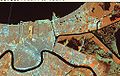
Same image but with the RGB rastors set for 4,5,7 to highlight water areas.

New Orleans, Louisiana on September 2, 2005 following damage done by Hurricane Katrina on August 28.

Same image, with the RGB rastors were set to 4,5,7, which has picked up the presence of water remaining within what should be dry land.


See also[edit]
References[edit]
Categories: [Technology]
↧ Download as ZWI file | Last modified: 02/14/2023 13:03:44 | 115 views
☰ Source: https://www.conservapedia.com/Remote_sensing | License: CC BY-SA 3.0
 ZWI signed: