Casius Quadrangle
 From Handwiki
  Map of Casius quadrangle from Mars Orbiter Laser Altimeter (MOLA) data. The highest elevations are red and the lowest are blue. | |
| Coordinates | [ ⚑ ] : 47°30′N 270°00′W / 47.5°N 270°W |
|---|---|

The Casius quadrangle is one of a series of 30 quadrangle maps of Mars used by the United States Geological Survey (USGS) Astrogeology Research Program. The quadrangle is located in the north-central portion of Mars’ eastern hemisphere and covers 60° to 120° east longitude (240° to 300° west longitude) and 30° to 65° north latitude. The quadrangle uses a Lambert conformal conic projection at a nominal scale of 1:5,000,000 (1:5M). The Casius quadrangle is also referred to as MC-6 (Mars Chart-6).[1] Casius quadrangle contains part of Utopia Planitia and a small part of Terra Sabaea. The southern and northern borders of the Casius quadrangle are approximately 3,065 km and 1,500 km wide, respectively. The north to south distance is about 2,050 km (slightly less than the length of Greenland).[2] The quadrangle covers an approximate area of 4.9 million square km, or a little over 3% of Mars’ surface area.[3]
Origin of name
Casius is the name of a telescopic albedo feature located at 40° N and 100° E on Mars. The feature was named by Schiaparelli in 1888 after Mt Casius in Egypt, famous in antiquity for the nearby coastal marshes in which whole armies were reputed to have drowned. The name was approved by the International Astronomical Union (IAU) in 1958.[4]
Physiography and geology
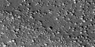
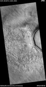
The high latitude Casius quadrangle bears several features that are believed to indicate the presence of ground ice. Patterned ground is one such feature. Usually, polygonal shapes are found poleward of 55 degrees latitude.[5] Other features associated with ground ice are Scalloped Topography,[6] Ring Mold Craters, and Concentric Crater Fill.

Map of Casius quadrangle with major features labeled.
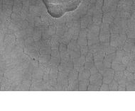
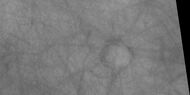
Patterned ground in the form of polygonal features is associated with ground ice. It is rare to be found this far south (45 degrees north latitude). Picture taken by Mars Global Surveyor.
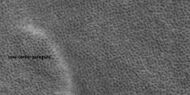
Field of low center polygons near crater, as seen by HiRISE under HiWish program These features are common where the ground freezes and thaws.

Periglacial Forms in Utopia, as seen by HiRISE. Click on image to see patterned ground and scalloped topography.
Polygonal patterned ground
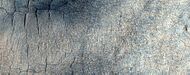
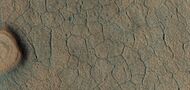
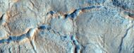
Polygonal, patterned ground is quite common in some regions of Mars, especially in scalloped topography.[7][8] It is commonly believed to be caused by the sublimation of ice from the ground. Sublimation is the direct change of solid ice to a gas. This is similar to what happens to dry ice on the Earth. Places on Mars that display polygonal ground may indicate where future colonists can find water ice. Patterned ground forms in a mantle layer that fell from the sky when the climate was different.[9] Polygonal ground is generally divided into two kinds: high center and low center. The middle of a high center polygon is 10 meters across and its troughs are 2–3 meters wide. Low center polygons are 5–10 meters across and the boundary ridges are 3–4 meters wide. Low center polygons have been proposed as a marker for ground ice.[10]

Low center polygons, shown with arrows, as seen by HiRISE under HiWish program Image was enlarged with HiView.

High center polygons, shown with arrows, as seen by HiRISE under HiWish program. Image enlarged with HiView.

Scalloped terrain labeled with both low center polygons and high center polygons, as seen by HiRISE under HiWish program Image enlarged with HiView.
High and low center polygons, as seen by HiRISE under HiWish program Location is Casius quadrangle. Image enlarged with HiView.

High and low-centered polygons in a region of scalloped terrain, as seen by HiRISE under HiWish program
Low-centered polygons in a region of scalloped terrain, as seen by HiRISE under HiWish program

Crater floor with low center polygons, as seen by HiRISE under HiWish program

Color view of polygonal ground, as seen by HiRISE under HiWish program
Close, color view of patterned ground, as seen by HiRISE under HiWish program
Close, color view of polygonal ground, as seen by HiRISE under HiWish program

Large and small polygonal ground, as seen by HiRISE under HiWish program Area with small, low-center polygons is labeled.
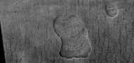
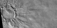
Ring mold craters
Ring mold craters look like the ring molds used in baking. They are believed to be caused by an impact into ice. The ice is covered by a layer of debris. They are found in parts of Mars that have buried ice. Laboratory experiments confirm that impacts into ice result in a "ring mold shape."[11][12][13] They may be an easy way for future colonists of Mars to find water ice.

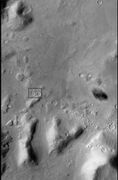
CTX context image for next image taken with HiRISE. Box indicates image footprint of following image.

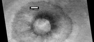
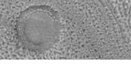
Possible ring mold crater, as seen by HiRISE under the HiWish program. Crater shape is due to impact into ice.

Ring-mold craters form when an impact goes through to an ice layer. The rebound forms the ring-mold shape, and then dust and debris settle on the top to insulate the ice.
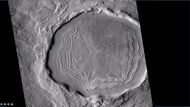
Concentric crater fill
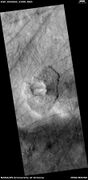
Concentric crater fill is when the floor of a crater is mostly covered with a large number of parallel ridges.[14] They are thought to result from a glacial type of movement.[15][16] Sometimes boulders are found on concentric crater fill; it is believed they fell off crater wall, and then were transported away from the wall with the movement of the glacier.[17][18] Erratics on Earth were carried by similar means. Based on accurate topography measures of height at different points in these craters and calculations of how deep the craters should be based on their diameters, it is thought that the craters are 80% filled with mostly ice. That is, they hold hundreds of meters of material that probably consists of ice with a few tens of meters of surface debris.[19] The ice accumulated in the crater from snowfall in previous climates.[20]
High resolution pictures taken with HiRISE reveal that some of the surfaces of concentric crater fill are covered with strange patterns called closed-cell and open-cell brain terrain. The terrain resembles a human brain. It is believed to be caused by cracks in the surface accumulating dust and other debris, together with ice sublimating from some of the surfaces.[21]
Wide-view of concentric crater fill, as seen by HiRISE.

Concentric Crater Fill Close-up of near the top of previous image, as seen by HiRISE. The surface debris covers water ice.
Crater with concentric crater fill, as seen by CTX (on Mars Reconnaissance Orbiter). Location is Casius quadrangle.
Well-developed hollows, as seen by HiRISE under the HiWish program. Location is the Casius quadrangle. Note: this is an enlargement of the previous image that was taken by CTX.

Close-up that shows cracks containing pits on the floor of a crater containing concentric crater fill, as seen by HiRISE under HiWish program.
Close-up that shows cracks containing pits on the floor of a crater, as seen by HiRISE under HiWish program. Cracks may start as a line of pits that enlarge, then join.
Crater floor showing concentric crater fill, as seen by HiRISE under HiWish program
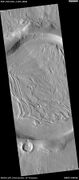
Glaciers
Old glaciers are found in many places on Mars. Some are associated with gullies.

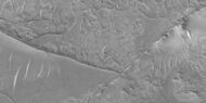
Glacier on a crater floor, as seen by HiRISE under HiWish program The cracks in the glacier may be crevasses. There is also a gully system on the crater wall.
Valley showing Lineated valley fill, as seen by HiRISE under HiWish program Linear valley flow is caused by ice movements.
Flow, as seen by HiRISE under HiWish program
Nilosyrtis
Nilosyrtis runs from about 280 to 304 degrees west longitude, so like several other features, it sits in more than one quadrangle. Part of Nilosyrtis is in the Ismenius Lacus quadrangle, the rest is in Casius quadrangle.

Channel in Nilosyrtis that was formed when a lake in a 45-mile-wide crater drained, as seen by THEMIS.

Landing Site in Nilosyrtis, as seen by THEMIS. Site is flat and contains water-altered clay minerals.

Nilosyrtis, as seen by HiRISE. Click on image to see layers.
Climate change caused ice-rich features
Many features on Mars, including many in Casius quadrangle, are believed to contain large amounts of ice. The most popular model for the origin of the ice is climate change from large changes in the tilt of the planet's rotational axis. At times the tilt has even been greater than 80 degrees[22][23] Large changes in the tilt explains many ice-rich features on Mars.
Studies have shown that when the tilt of Mars reaches 45 degrees from its current 25 degrees, ice is no longer stable at the poles.[24] Furthermore, at this high tilt, stores of solid carbon dioxide (dry ice) sublimate, thereby increasing the atmospheric pressure. This increased pressure allows more dust to be held in the atmosphere. Moisture in the atmosphere will fall as snow or as ice frozen onto dust grains. Calculations suggest this material will concentrate in the mid-latitudes.[25][26] General circulation models of the Martian atmosphere predict accumulations of ice-rich dust in the same areas where ice-rich features are found.[27] When the tilt begins to return to lower values, the ice sublimates (turns directly to a gas) and leaves behind a lag of dust.[28][29] The lag deposit caps the underlying material so with each cycle of high tilt levels, some ice-rich mantle remains behind.[30] Note, that the smooth surface mantle layer probably represents only relative recent material.
Mars Science Laboratory
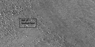
Nilosyrtis is one of the sites proposed as a landing site for the Mars Science Laboratory. However, it did not make the final cut. It was in the top 7, but not in the top 4. The aim of the Mars Science Laboratory is to search for signs of ancient life. It is hoped that a later mission could then return samples from sites identified as probably containing remains of life. To safely bring the craft down, a 12-mile-wide, smooth, flat circle is needed. Geologists hope to examine places where water once ponded.[31] They would like to examine sediment layers.
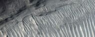
Layers
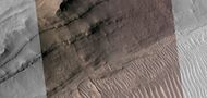
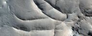
Many places on Mars show rocks arranged in layers. A detailed discussion of layering with many Martian examples can be found in Sedimentary Geology of Mars.[32] Rock can form layers in a variety of ways. Volcanoes, wind, or water can produce layers.[33] Layers may be formed by groundwater rising up depositing minerals and cementing sediments. The hardened layers are consequently more protected from erosion. This process may occur instead of layers forming under lakes.
Layers, as seen by HiRISE under HiWish program.
Layers in Monument Valley. These are accepted as being formed, at least in part, by water deposition. Since Mars contains similar layers, water remains as a major cause of layering on Mars.
Wide view of layers, as seen by HiRISE under HiWish program
Close view of layers, as seen by HiRISE under HiWish program
Close view of layers, as seen by HiRISE under HiWish program A ridge cuts across the layers at a right angle.
Close view of layers, as seen by HiRISE under HiWish program A ridge cuts across the layers at a right angle.
Close view of layers, as seen by HiRISE under HiWish program A ridge cuts across the layers at a right angle.
Close view of layers, as seen by HiRISE under HiWish program Part of picture is in color. A ridge cuts across the layers at a right angle.
Gullies
Martian gullies are small, incised networks of narrow channels and their associated downslope sediment deposits, found on the planet of Mars. They are named for their resemblance to terrestrial gullies. First discovered on images from Mars Global Surveyor, they occur on steep slopes, especially on the walls of craters. Usually, each gully has a dendritic alcove at its head, a fan-shaped apron at its base, and a single thread of incised channel linking the two, giving the whole gully an hourglass shape.[34] They are believed to be relatively young because they have few, if any craters. A subclass of gullies is also found cut into the faces of sand dunes which themselves considered to be quite young. On the basis of their form, aspects, positions, and location amongst and apparent interaction with features thought to be rich in water ice, many researchers believed that the processes carving the gullies involve liquid water. However, this remains a topic of active research. As soon as gullies were discovered,[34] researchers began to image many gullies over and over, looking for possible changes. By 2006, some changes were found.[35] Later, with further analysis it was determined that the changes could have occurred by dry granular flows rather than being driven by flowing water.[36][37][38] With continued observations many more changes were found in Gasa Crater and others.[39] With more repeated observations, more and more changes have been found; since the changes occur in the winter and spring, experts are tending to believe that gullies were formed from dry ice. Before-and-after images demonstrated the timing of this activity coincided with seasonal carbon-dioxide frost and temperatures that would not have allowed for liquid water. When dry ice frost changes to a gas, it may lubricate dry material to flow especially on steep slopes.[40][41][42] In some years frost, perhaps as thick as 1 meter.
Gullies in crater, as seen by HiRISE under HiWish program

Close view of gully in crater, as seen by HiRISE
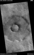
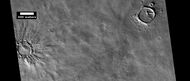
Pedestal craters
A pedestal crater is a crater with its ejecta sitting above the surrounding terrain and thereby forming a raised platform (like a pedestal). They form when an impact crater ejects material which forms an erosion-resistant layer, thus causing the immediate area to erode more slowly than the rest of the region.[43] [44] Some pedestals have been accurately measured to be hundreds of meters above the surrounding area. This means that hundreds of meters of material were eroded away. The result is that both the crater and its ejecta blanket stand above the surroundings. Pedestal craters were first observed during the Mariner missions.[45][46][47][48]

Pedestal crater, seen by HiRISE. The ejecta blanket (asymmetrical because the asteroid came at a low angle from the northeast) protected the underlying material from erosion, so the crater looks elevated.
In a close-up of the east (right) side of the previous image, polygons on a lobe at the crater's margin are thought to indicate ice lies under the protective top.
Pedestal crater, as seen by HiRISE under HiWish program Dark lines are dust devil tracks.

pedestal crater, as seen by HiRISE under HiWish program Scallops are forming at the bottom edge of the pedestal.
Pedestal crater with boulders along rim. Such craters are called "halo craters."[49] Picture taken with HiRISE under HiWish program.
Close view of boulders on lower left of crater rim Box is the size of a football field, so boulders are roughly the size of cars or small houses. Picture taken with HiRISE under HiWish program.
Close view of boulders along crater rim Boulders are roughly the size of cars or small houses. Picture taken with HiRISE under HiWish program.
Pedestal crater and dust devil tracks, as seen by HiRISE under HiWish program

Close view of Pedestal crater and dust devil tracks, as seen by HiRISE under HiWish program
Pedestal crater, as seen by HiRISE under HiWish program
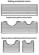
Pedestal craters form when the ejecta from impacts protect the underlying material from erosion. As a result of this process, craters appear perched above their surroundings
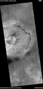
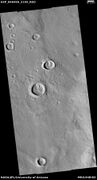
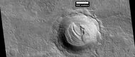
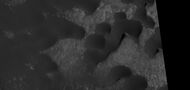
Cones
Some locations on Mars display a large number of cones. Many have pits at the top. There have been a number of ideas put forth as to their origins. Some are in the Casius quadrangle like the ones below.

Cones along with a band of material of unknown origin. Picture taken with HiRISE under HiWish program.

Cones along with a band of material of unknown origin. Picture taken with HiRISE under HiWish program. Arrows point to the edge of bands.
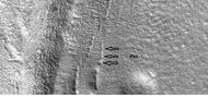
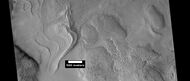
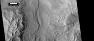
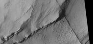
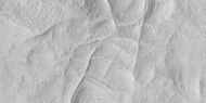
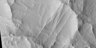
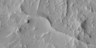
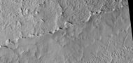
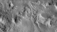
Linear ridge networks
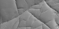
Linear ridge networks are found in various places on Mars in and around craters.[50] Ridges often appear as mostly straight segments that intersect in a lattice-like manner. They are hundreds of meters long, tens of meters high, and several meters wide. It is thought that impacts created fractures in the surface, these fractures later acted as channels for fluids. Fluids cemented the structures. With the passage of time, surrounding material was eroded away, thereby leaving hard ridges behind. [51] Since the ridges occur in locations with clay, these formations could serve as a marker for clay which requires water for its formation.[52][53][54]

Network of ridges, as seen by HiRISE under HiWish program Ridges may be formed in various ways.
Color, close-up of ridges seen in previous image, as seen by HiRISE under HiWish program

More ridges from the same place as the previous two images, as seen by HiRISE under HiWish program
Ridge network close-up, as seen by HiRISE under HiWish program

Linear ridge network, as seen by HiRISE under HiWish program
Close-up and color image of previous image of linear ridge network, as seen by HiRISe under HiWish program
Close-up of ridges, as seen by HiRISE under HiWish program
Close-up of ridges, as seen by HiRISE under HiWish program
More linear ridge networks, as seen by HiRISE under HiWish program
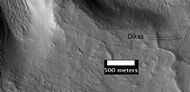
These ridges may be dikes or joints formed as a consequence of a crater impact. as seen by HiRISE under the HiWish program.

Ridges, as seen by HiRISE under HiWish program

Wide view of network of ridges, as seen by HiRISE under HiWish program Portions of this image are enlarged in following images.

Close view of network of ridges, as seen by HiRISE under HiWish program This is an enlargement of a previous image.

Close view of network of ridges, as seen by HiRISE under HiWish program This is an enlargement of a previous image. Box shows the size of a football field.
Close view of network of ridges, as seen by HiRISE under HiWish program This is an enlargement of a previous image.
Close view of ridges, as seen by HiRISE under HiWish program This is an enlargement of a previous image. A small mesa in the image displays layers.
Close, color view of network of ridges, as seen by HiRISE under HiWish program This is an enlargement of a previous image.

Wide view of ridge networks, as seen by HiRISE under HiWish program

Close view of ridge networks, as seen by HiRISE under HiWish program
Close view of ridge networks, as seen by HiRISE under HiWish program Many boulders are visible.
Close view of ridge networks, as seen by HiRISE under HiWish program Ridges of different sizes are visible in this image.

Wide view of ridges, as seen by HiRISE under HiWish program A channel segment is also visible in the image.

Close, color view of ridges, as seen by HiRISE under HiWish program
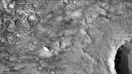
Scalloped terrain
Scalloped depressions are believed to form from the removal of subsurface material, possibly interstitial ice, by sublimation (direct transition of a material from the solid to the gas phase with no intermediate liquid stage). This process may still be happening at present.[55] This topography may be of great importance for future colonization of Mars because it may point to deposits of pure ice.[56]
On November 22, 2016, NASA reported finding a large amount of underground ice in the Utopia Planitia region of Mars.[57] The volume of water detected has been estimated to be equivalent to the volume of water in Lake Superior.[58][59] The volume of water ice in the region were based on measurements from the ground-penetrating radar instrument on Mars Reconnaissance Orbiter, called SHARAD. From the data obtained from SHARAD, “dielectric permittivity”, or the dielectric constant was determined. The dielectric constant value was consistent with a large concentration of water ice.[60][61][62]

Scalloped terrain, as seen by HiRISE under HiWish program

Scalloped ground, as seen by HiRISE under HiWish program.
Close-up of scalloped ground, as seen by HiRISE under HiWish program. Surface is divided into polygons; these forms are common where ground freezes and thaws. Note: this is an enlargement of a previous image.
Scalloped ground, as seen by HiRISE under HiWish program.

Close-up of scalloped ground, as seen by HiRISE under HiWish program. Surface is divided into polygons; these forms are common where ground freezes and thaws. Note: this is an enlargement of a previous image.

Wide view of scalloped terrain showing depressions merging, as seen by HiRISE under HiWish program

Scalloped terrain, as seen by HiRISE under HiWish program
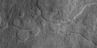
Scalloped terrain, as seen by HiRISE under HiWish program
Scalloped terrain, as seen by HiRISE under HiWish program
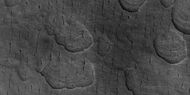
Scalloped terrain, as seen by HiRISE under HiWish program
Scalloped terrain and polygonal ground, as seen by HiRISE under HiWish program
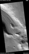
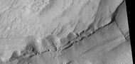
Layers in craters
Layers along slopes, especially along crater walls are believed to be the remains of a once wide spread material that has mostly been eroded away.[63]

Layers in craters, as seen by HiRISE under the HiWish program. Area was probably covered over by these layers; the layers have now eroded away except for the protected interior of craters.

Layers in craters, as seen by HiRISE under HiWish program
Layers in craters, as seen by HiRISE under HiWish program

Close view of layers in craters, as seen by HiRISE under HiWish program Note: this is an enlargement of the previous image.
CTX image showing area in next image.

Wide view of deposits in craters, as seen by HiRISE under HiWish program
Layered deposit in craters, as seen by HiRISE under HiWish program

Layered features in craters, as seen by HiRISE under HiWish program
Layered features in craters, as seen by HiRISE under HiWish program
Close view of layered feature in crater, as seen by HiRISE under HiWish program Feature seems to be higher than parts of the crater rim.
Layered feature in crater, as seen by HiRISE under HiWish program

Layered feature in crater, as seen by HiRISE under HiWish program

Close view of mantle near a layered feature, as seen by HiRISE under HiWish program
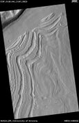
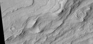
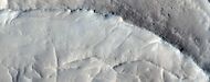
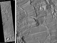
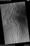
Dipping layers
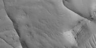
Dipping layers are common in some regions of Mars. They may be the remains of mantle layers.
Dipping layers and layers of mantle, as seen by HiRISE under HiWish program The dipping layers look similar to layers of mantle.
Close view of mantle near the dipping layers, as seen by HiRISE under HiWish program
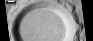
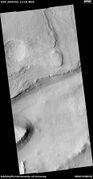
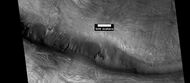
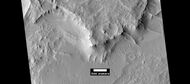
Craters
Impact craters generally have a rim with ejecta around them, in contrast volcanic craters usually do not have a rim or ejecta deposits. As craters get larger (greater than 10 km in diameter) they usually have a central peak.[64] The peak is caused by a rebound of the crater floor following the impact.[65] If one measures the diameter of a crater, the original depth can be estimated with various ratios. Because of this relationship, researchers have found that many Martian craters contain a great deal of material; much of it is believed to be ice deposited when the climate was different.[66] Sometimes craters expose layers that were buried. Rocks from deep underground are tossed onto the surface. Hence, craters can show us what lies deep under the surface.

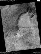
Crater in the Adamas Labyrinthus Region, as seen by HiRISE. The original image shows many interesting details.
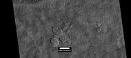
Bacolor Crater Ejecta, as seen by HiRISE. Scale bar is 1000 meters long.

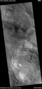
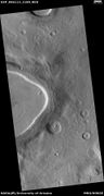
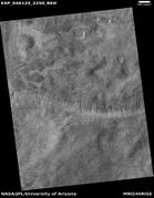
Renaudot Crater, as seen by CTX camera (on Mars Reconnaissance Orbiter). Dark dots are dunes.

Dunes and old glaciers in Renaudot Crater, as seen by CTX camera (on Mars Reconnaissance Orbiter). Arrows point to old glaciers along the crater wall. Note: this is an enlargement of the previous image.
Baldet Crater (Martian Crater), as seen by CTX camera (on Mars Reconnaissance Orbiter).
Channels on North wall of Baldet Crater, as seen by CTX camera (on Mars Reconnaissance Orbiter). Note: this is an enlargement of the previous image of Baldet Crater.
Dunes on floor of Baldet Crater, as seen by CTX camera (on Mars Reconnaissance Orbiter). Note: this is an enlargement of a previous image of Baldet Crater.
Ring of boulders around rim of old crater with dust devil tracks in the background, as seen by HiRISE under HiWish program
Dust devil tracks
Many areas on Mars experience the passage of giant dust devils. These dust devils leave tracks on the surface of mars because they disturb a thin coating of fine bright dust that covers most of the Martian surface. When a dust devil goes by it blows away the coating and exposes the underlying dark surface. Within a few weeks, the dark track assumes its former bright colour, either by being re-covered through wind action or due to surface oxidation through exposure to sunlight and air.

Dust devil tracks, as seen by HiRISE under HiWish program. Location is Casius quadrangle.
Dust devil tracks, as seen by HiRISE under HiWish program. Location is Casius quadrangle.
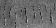
Pitted surface
Wide view of a surface with lines of pits, as seen by HiRISE under HiWish program.
Close view of lines of pits, as seen by HiRISE under HiWish program

Close, color view of lines of pits, as seen by HiRISE under HiWish program
Wide view of lines of pits, as seen by HiRISE under HiWish program
Close view of lines of pits, as seen by HiRISE under HiWish program
Wide view of fractured surface and pits along wall of crater, as seen by HiRISE under HiWish program
Close view of cracks and boulders, as seen by HiRISE under HiWish program

Close view of pits and boulders along crater wall, as seen by HiRISE under HiWish program
Lines of pits, as seen by HiRISE under HiWish program
Close view of pits and brain terrain, as seen by HiRISE under HiWish program
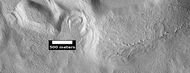
Other views from Casius

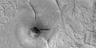
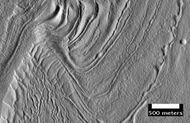
Astapus Colles Mounds and Knobs, as seen by HiRISE. Scale bar is 500 meters long.
Surface of Nilosyrtis Mensae showing ridges and cracks, as seen by HiRISE, under the HiWish program.

Another view of surface of Nilosyrtis Mensae, as seen by HiRISE, under the HiWish program.

Pits that seem to be forming cracks, as seen by HiRISE under HiWish program.
Holes and hollows on crater floor, as seen by HiRISE under HiWIsh program.

Ribbed terrain, as seen by HiRISE under HiWish program
Ice layers in crater, as seen by HiRISE under HiWish program

Close, color view of ice layers in crater in previous image, as seen by HiRISE under HiWish program Both, open and closed brain terrain are visible.
Dunes, as seen by HiRISE under HiWish program
Other Mars quadrangles
Interactive Mars map
Error: Image is invalid or non-existent.
See also
- Climate of Mars
- Geology of Mars
- Patterned ground
- Water on Mars
References
- ↑ Davies, M.E.; Batson, R.M.; Wu, S.S.C. "Geodesy and Cartography" in Kieffer, H.H.; Jakosky, B.M.; Snyder, C.W.; Matthews, M.S., Eds. Mars. University of Arizona Press: Tucson, 1992.
- ↑ Distances calculated using NASA World Wind measuring tool. http://worldwind.arc.nasa.gov/.
- ↑ Approximated by integrating latitudinal strips with an area of R^2 (L1-L2)(cos(A)dA) from 30° to 65° latitude; where R = 3889 km, A is latitude, and angles expressed in radians. See: https://stackoverflow.com/questions/1340223/calculating-area-enclosed-by-arbitrary-polygon-on-earths-surface.
- ↑ USGS Gazetteer of Planetary Nomenclature. Mars. http://planetarynames.wr.usgs.gov/.
- ↑ Mangold, N. 2005. High latitude patterned grounds on Mars: Classification, distribution and climatic control. Icarus. 174-336-359.
- ↑ "HiRISE | Scalloped Topography in Peneus Patera Crater". http://hiroc.lpl.arizona.edu/images/PSP/diafotizo.php?ID=PSP_002296_1215.
- ↑ Malin, M., Edgett, K. 2001. Mars Global Surveyor Mars Orbiter Camera: Interplanetary cruise through primary mission. J. Geophys. Res. 106 (E10), 23429–23540.
- ↑ Kreslavsky, M., Head, J. 2000. Kilometer-scale roughness on Mars: Results from MOLA data analysis. J. Geophys. Res. 105 (E11), 26695–26712.
- ↑ Mustard, J., et al. 2001. Evidence for recent climate change on Mars from the identification of youthful near-surface ground ice. Nature 412 (6845), 411–414.
- ↑ Soare, R., et al. 2018. POSSIBLE ICE-WEDGE POLYGONISATION IN UTOPIA PLANITIA, MARS, AND ITS POLEWARD LATITUDINAL-GRADIENT. 49th Lunar and Planetary Science Conference 2018 (LPI Contrib. No. 2083). 1084.pdf
- ↑ Kress, A., J. Head. 2008. Ring-mold craters in lineated valley fill and lobate debris aprons on Mars: Evidence for subsurface glacial ice. Geophys.Res. Lett: 35. L23206-8
- ↑ Baker, D. et al. 2010. Flow patterns of lobate debris aprons and lineated valley fill north of Ismeniae Fossae, Mars: Evidence for extensive mid-latitude glaciation in the Late Amazonian. Icarus: 207. 186-209
- ↑ Kress., A. and J. Head. 2009. Ring-mold craters on lineated valley fill, lobate debris aprons, and concentric crater fill on Mars: Implications for near-surface structure, composition, and age. Lunar Planet. Sci: 40. abstract 1379
- ↑ "HiRISE |
Notice: Undefined variable: Title in /Data/Www_hirise/Hiroc.LPL.arizona.edu/Images/PSP/Diafotizo.PHP on line 23
". http://hiroc.lpl.arizona.edu/images/PSP/diafotizo.php?ID=PSP_111926_2185. - ↑ Head, J. et al. 2006. Extensive valley glacier deposits in the northern mid-latitudes of Mars: Evidence for late Amazonian obliquity-driven climate change. Earth Planet. Sci Lett: 241. 663-671.
- ↑ Levy, J. et al. 2007. Lineated valley fill and lobate debris apron stratigraphy in Nilosyrtis Mensae, Mars: Evidence for phases of glacial modification of the dichotomy boundary. J. Geophys. Res.: 112.
- ↑ Marchant, D. et al. 2002. Formation of patterned ground and sublimation till over Miocene glacier ice in Beacon valley, southern Victorialand, Antarctica. Geol. Soc. Am. Bull:114. 718-730.
- ↑ Head, J. and D. Marchant. 2006. Modification of the walls of a Noachian crater in northern Arabia Terra (24E, 39N) during mid-latitude Amazonian glacial epochs on Mars: Nature and evolution of lobate debris aprons and their relationships to lineated valley fill and glacial systems. Lunar Planet. Sci: 37. Abstract # 1126.
- ↑ Garvin, J. et al. 2002. Global geometric properties of martian impact craters. Lunar Planet. Sci: 33. Abstract # 1255.
- ↑ Kreslavsky, M. and J. Head. 2006. Modification of impact craters in the northern planes of Mars: Implications for the Amazonian climate history. Meteorit. Planet. Sci.: 41. 1633-1646
- ↑ Ley, J. et al. 2009. Concentric crater fill in Utopia Planitia: History and interaction between glacial "brain terrain" and periglacial processes. Icarus: 202. 462-476.
- ↑ Touma J. and J. Wisdom. 1993. The Chaotic Obliquity of Mars. Science 259, 1294-1297.
- ↑ Laskar, J., A. Correia, M. Gastineau, F. Joutel, B. Levrard, and P. Robutel. 2004. Long term evolution and chaotic diffusion of the insolation quantities of Mars. Icarus 170, 343-364.
- ↑ Levy, J., J. Head, D. Marchant, D. Kowalewski. 2008. Identification of sublimation-type thermal contraction crack polygons at the proposed NASA Phoenix landing site: Implications for substrate properties and climate-driven morphological evolution. Geophys. Res. Lett. 35. doi:10.1029/2007GL032813.
- ↑ Levy, J., J. Head, D. Marchant. 2009a. Thermal contraction crack polygons on Mars: Classification, distribution, and climate implications from HiRISE observations. J. Geophys. Res. 114. doi:10.1029/2008JE003273.
- ↑ Hauber, E., D. Reiss, M. Ulrich, F. Preusker, F. Trauthan, M. Zanetti, H. Hiesinger, R. Jaumann, L. Johansson, A. Johnsson, S. Van Gaselt, M. Olvmo. 2011. Landscape evolution in Martian mid-latitude regions: insights from analogous periglacial landforms in Svalbard. In: Balme, M., A. Bargery, C. Gallagher, S. Guta (eds). Martian Geomorphology. Geological Society, London. Special Publications: 356. 111-131
- ↑ Laskar, J., A. Correia, M. Gastineau, F. Joutel, B. Levrard, and P. Robutel. 2004. Long term evolution and chaotic diffusion of the insolation quantities of Mars. Icarus 170, 343-364.
- ↑ Mellon, M., B. Jakosky. 1995. The distribution and behavior of Martian ground ice during past and present epochs. J. Geophys. Res. 100, 11781–11799.
- ↑ Schorghofer, N., 2007. Dynamics of ice ages on Mars. Nature 449, 192–194.
- ↑ Madeleine, J., F. Forget, J. Head, B. Levrard, F. Montmessin. 2007. Exploring the northern mid-latitude glaciation with a general circulation model. In: Seventh International Conference on Mars. Abstract 3096.
- ↑ "The Floods of Iani Chaos | Mars Odyssey Mission THEMIS". http://themis.asu.edu/features/ianichaos.
- ↑ Grotzinger, J. and R. Milliken (eds.). 2012. Sedimentary Geology of Mars. SEPM.
- ↑ "HiRISE | High Resolution Imaging Science Experiment". Hirise.lpl.arizona.edu?psp_008437_1750. http://hirise.lpl.arizona.edu?PSP_008437_1750.
- ↑ 34.0 34.1 Malin, M., Edgett, K. 2000. Evidence for recent groundwater seepage and surface runoff on Mars. Science 288, 2330–2335.
- ↑ Malin, M., K. Edgett, L. Posiolova, S. McColley, E. Dobrea. 2006. Present-day impact cratering rate and contemporary gully activity on Mars. Science 314, 1573_1577.
- ↑ Kolb, et al. 2010. Investigating gully flow emplacement mechanisms using apex slopes. Icarus 2008, 132-142.
- ↑ McEwen, A. et al. 2007. A closer look at water-related geological activity on Mars. Science 317, 1706-1708.
- ↑ Pelletier, J., et al. 2008. Recent bright gully deposits on Mars wet or dry flow? Geology 36, 211-214.
- ↑ NASA/Jet Propulsion Laboratory. "NASA orbiter finds new gully channel on Mars." ScienceDaily. ScienceDaily, 22 March 2014. www.sciencedaily.com/releases/2014/03/140322094409.htm
- ↑ NASA.gov
- ↑ "HiRISE | Activity in Martian Gullies (ESP_032078_1420)". http://hirise.lpl.arizona.edu/ESP_032078_1420.
- ↑ "Gullies on Mars Carved by Dry Ice, Not Water". 16 July 2014. http://www.space.com/26534-mars-gullies-dry-ice.html.
- ↑ S.J. Kadish, J.W. Head. 2011. Impacts into non-polar ice-rich paleodeposits on Mars: excess ejecta craters, perched craters and pedestal craters as clues to Amazonian climate history. Icarus, 215, pp. 34-46
- ↑ S.J. Kadish, J.W. Head. 2014. The ages of pedestal craters on Mars: evidence for a late Amazonian extended periodic emplacement of decameters-thick mid-latitude ice deposits. Planet. Space Sci., 91, pp. 91-100
- ↑ http://hirise.lpl.eduPSP_008508_1870[yes|permanent dead link|dead link}}]
- ↑ Bleacher, J. and S. Sakimoto. Pedestal Craters, A Tool For Interpreting Geological Histories and Estimating Erosion Rates. LPSC
- ↑ "Mars Odyssey Mission THEMIS: Feature Image: Pedestal Craters in Utopia". http://themis.asu.edu/feature_utopiacraters.
- ↑ McCauley, J. F. (1973). "Mariner 9 evidence for wind erosion in the equatorial and mid-latitude regions of Mars". Journal of Geophysical Research 78 (20): 4123–4137. doi:10.1029/JB078i020p04123. Bibcode: 1973JGR....78.4123M.
- ↑ Levy, J. et al. 2008. Origin and arrangement of boulders on the martian northern plains: Assessment of emplacement and modification environments In 39th Lunar and Planetary Science Conference, Abstract #1172. League City, TX
- ↑ Head, J., J. Mustard. 2006. Breccia dikes and crater-related faults in impact craters on Mars: Erosion and exposure on the floor of a crater 75 km in diameter at the dichotomy boundary, Meteorit. Planet Science: 41, 1675-1690.
- ↑ Kerber, L., et al. 2017. Polygonal ridge networks on Mars: Diversity of morphologies and the special case of the Eastern Medusae Fossae Formation. Icarus. Volume 281. Pages 200-219
- ↑ Mangold et al. 2007. Mineralogy of the Nili Fossae region with OMEGA/Mars Express data: 2. Aqueous alteration of the crust. J. Geophys. Res., 112, doi:10.1029/2006JE002835.
- ↑ Mustard et al., 2007. Mineralogy of the Nili Fossae region with OMEGA/Mars Express data: 1. Ancient impact melt in the Isidis Basin and implications for the transition from the Noachian to Hesperian, J. Geophys. Res., 112.
- ↑ Mustard et al., 2009. Composition, Morphology, and Stratigraphy of Noachian Crust around the Isidis Basin, J. Geophys. Res., 114, doi:10.1029/2009JE003349.
- ↑ "Scalloped Topography in Peneus Patera Crater". HiRISE Operations Center. 2007-02-28. http://hiroc.lpl.arizona.edu/images/PSP/diafotizo.php?ID=PSP_002296_1215.
- ↑ Dundas, C., S. Bryrne, A. McEwen. 2015. Modeling the development of martian sublimation thermokarst landforms. Icarus: 262, 154-169.
- ↑ "Huge Underground Ice Deposit on Mars is Bigger Than New Mexico". 22 November 2016. http://www.space.com/34811-mars-ice-more-water-than-lake-superior.html.
- ↑ Staff (November 22, 2016). "Scalloped Terrain Led to Finding of Buried Ice on Mars". NASA. http://photojournal.jpl.nasa.gov/catalog/PIA21136.
- ↑ "Lake of frozen water the size of New Mexico found on Mars – NASA". The Register. November 22, 2016. https://www.theregister.co.uk/2016/11/22/nasa_finds_ice_under_martian_surface/.
- ↑ Bramson, A, et al. 2015. Widespread excess ice in Arcadia Planitia, Mars. Geophysical Research Letters: 42, 6566-6574
- ↑ "Widespread, Thick Water Ice found in Utopia Planitia, Mars | Cassie Stuurman". https://planetarycassie.com/2016/11/04/widespread-thick-water-ice-found-in-utopia-planitia-mars/.
- ↑ Stuurman, C., et al. 2016. SHARAD detection and characterization of subsurface water ice deposits in Utopia Planitia, Mars. Geophysical Research Letters: 43, 9484_9491.
- ↑ Carr, M. 2001. Mars Global Surveyor observations of martian fretted terrain. J. Geophys. Res. 106, 23571-23593.
- ↑ "Stones, Wind, and Ice: A Guide to Martian Impact Craters". http://www.lpi.usra.edu/publications/slidesets/stones/.
- ↑ Hugh H. Kieffer (1992). Mars. University of Arizona Press. ISBN 978-0-8165-1257-7. https://books.google.com/books?id=NoDvAAAAMAAJ. Retrieved 7 March 2011.
- ↑ Garvin, J., et al. 2002. Global geometric properities of martian impact craters. Lunar Planet Sci. 33. Abstract @1255.
- ↑ Morton, Oliver (2002). Mapping Mars: Science, Imagination, and the Birth of a World. New York: Picador USA. p. 98. ISBN 0-312-24551-3.
- ↑ "Online Atlas of Mars". http://ralphaeschliman.com/id30.htm. Retrieved December 16, 2012.
- ↑ "PIA03467: The MGS MOC Wide Angle Map of Mars". NASA / Jet Propulsion Laboratory. February 16, 2002. http://photojournal.jpl.nasa.gov/catalog/PIA03467. Retrieved December 16, 2012.
External links
- Martian Ice - Jim Secosky - 16th Annual International Mars Society Convention
- https://www.youtube.com/watch?v=kpnTh3qlObk[T. Gordon Wasilewski - Water on Mars - 20th Annual International Mars Society Convention] Describes how to get water from ice in the ground
Mars | |||||||||||
|---|---|---|---|---|---|---|---|---|---|---|---|
Outline of Mars | |||||||||||
| Geography |
| ||||||||||
| Astronomy |
| ||||||||||
| Exploration |
| ||||||||||
| Related |
| ||||||||||
| |||||||||||
 |  |
Categories: [Casius quadrangle] [Mars]
↧ Download as ZWI file | Last modified: 07/25/2024 04:01:09 | 17 views
☰ Source: https://handwiki.org/wiki/Astronomy:Casius_quadrangle | License: CC BY-SA 3.0