Spot Height
 From Handwiki
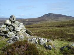
Spot height 479 near Arenig Fach in Snowdonia, Wales, marked by a cairn
A spot height is an exact point on a map with an elevation recorded beside it that represents its height above a given datum.[1] In the UK this is the Ordnance Datum. Unlike a bench-mark, which is marked by a disc or plate, there is no official indication of a spot height on the ground although, in open country, spot heights may sometimes be marked by cairns. In geoscience, it can be used for showing elevations on a map, alongside contours, bench marks, etc.
See also
- Surveying
- Benchmark (surveying)
- Triangulation station
References
- ↑ Whittow, John (1984). Dictionary of Physical Geography. London: Penguin, 1984, p. 506. ISBN:0-14-051094-X.
 |  |
Categories: [Cartography] [Geodesy] [Vertical position]
↧ Download as ZWI file | Last modified: 08/04/2024 10:57:33 | 9 views
☰ Source: https://handwiki.org/wiki/Spot_height | License: CC BY-SA 3.0
✘
ZWI is not signed. [what is this?]
ZWI viewer
by the  KSF
KSF