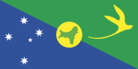
Christmas Island
 From Conservapedia
 Christmas Island is a territory of Australia located in the Indian Ocean south of Indonesia and northwest of Australia. It was first discovered by the British on December 25, 1643, hence the name of the island. The United Kingdom handed over sovereignty of the island to Australia in 1958 and it has remained in Australia's control since.
Christmas Island should not be confused with Kiritimati (formerly called Christmas Island; Kiritimati is the Gilbertese spelling of Christmas), which is an island in the Republic of Kiribati (pronounced Kiribass) [1]
Contents
Geography[edit]
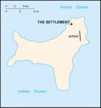
The total area of Christmas Island is 135 square kilometres, roughly about 3/4 the size of Washington D.C. It is almost totally covered by tropical rain forests. Sixty-three per cent of the island is now a national park.
Population[edit]
The population of the island is estimated at 1,402 people. The island itself having no indigenous people is mostly made up of Chinese (70%) and European (20%) immigrants.
Bibliography[edit]
Notes[edit]
| |||||||||||
Categories: [Islands] [Australia]
↧ Download as ZWI file | Last modified: 02/20/2023 06:06:52 | 34 views
☰ Source: https://www.conservapedia.com/Christmas_Island | License: CC BY-SA 3.0
 ZWI signed:

 KSF
KSF