Mittagong Formation
 From Handwiki
 | Mittagong Formation Stratigraphic range: Triassic PreЄ
Є
O
S
D
C
P
T
J
K
Pg
N
| |
|---|---|
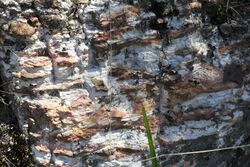 Mount Ku-ring-gai, Australia | |
| Type | Geological formation |
| Underlies | Ashfield Shale |
| Overlies | Hawkesbury sandstone |
| Thickness | up to 10 metres (30 ft) |
| Location | |
| Location | Sydney Basin |
| Country | Australia |
| Type section | |
| Region | Mittagong |
| Country | Australia |
| Thickness at type section | 15 metres |
The Mittagong Formation is a sedimentary rock unit in the Sydney Basin in eastern Australia .[1]
Formation
Laid down in the Triassic Period, it may be seen as an interval of interbedded fine-grained sandstone and shale between the Ashfield Shale (above) and the Hawkesbury sandstone (below). The maximum thickness around Sydney may be ten metres.[2] Near Town Hall railway station, the formation is 8 metres thick. In the type area at Mittagong it is 15 metres thick.
Whereabouts
In northern Sydney it can be seen in several areas, such as West Pymble[3] and Mount Ku-ring-gai.[4] This rock formation is associated with the critically endangered Sydney Turpentine-Ironbark Forest.[5]
See also
- Narrabeen group
References
- ↑ "Australian Museum - The Sydney Basin". http://australianmuseum.net.au/The-Sydney-Basin.
- ↑ "Geoscience Australia". http://dbforms.ga.gov.au/pls/www/geodx.strat_units.sch_full?wher=stratno=27489.
- ↑ Field Geology of New South Wales, Sydney Basin page 102
- ↑ Chris Herbert. Geology of the Sydney 1:100,000 Sheet 9130
- ↑ "Sydney Turpentine-Ironbark Forest". http://www.environment.gov.au/cgi-bin/sprat/public/publicshowcommunity.pl?id=38.
 |  |
Categories: [Sandstone formations] [Shale formations]
↧ Download as ZWI file | Last modified: 01/26/2025 11:24:24 | 1 views
☰ Source: https://handwiki.org/wiki/Earth:Mittagong_Formation | License: CC BY-SA 3.0
✘
ZWI is not signed. [what is this?]
ZWI viewer
by the  KSF
KSF